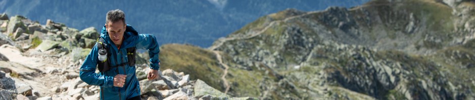
Kathleen is looking awfully angry right now! This Saturday morning I’ll set off on the classic Wainright Coast to Coast route across England, from the Irish Sea at St. Bees to the North Sea at Robin Hood’s Bay in the Northern Traverse race.
I’ve done all four iterations of the Northern Traverse that have been staged so far. I’m the only one to do so. It is a fantastic route that makes for a great race and a great adventurous experience. It’s normally much more pleasant than the usual battle with the elements I encounter in the likes of the Spine race.
This year is looking a bit different, to say the least. Throughout the day I’ve been reading in the news about a big Atlantic storm, named Kathleen by the Irish Met Office, approaching. It looks like it will be at its most severe on Saturday, just as we’re due to be running through the Lake District, the highest section of the race. There’s heavy rain forecast, as well as some very high wind speeds. This race is starting to look a little too “interesting”.
Oddly enough, it seems the storm will also be accompanied by relatively high temperatures. That’ll hopefully make things a little safer. But it will make balancing what gear to bring and wear a lot more tricky. I’m definitely glad to have a lot of excellent Outdry Extreme waterproof gear (Jacket, leggings, gloves, several pairs of shoes) that gives me confidence that there’ll be nobody in the race better equipped to deal with the storm than me!
The first time I participated in this race, it was a little later in the year, and most of the race was in beautiful summer days and nights. This looks like it will be completely the opposite. It’ll be interesting to find out how the route feels in comparison.
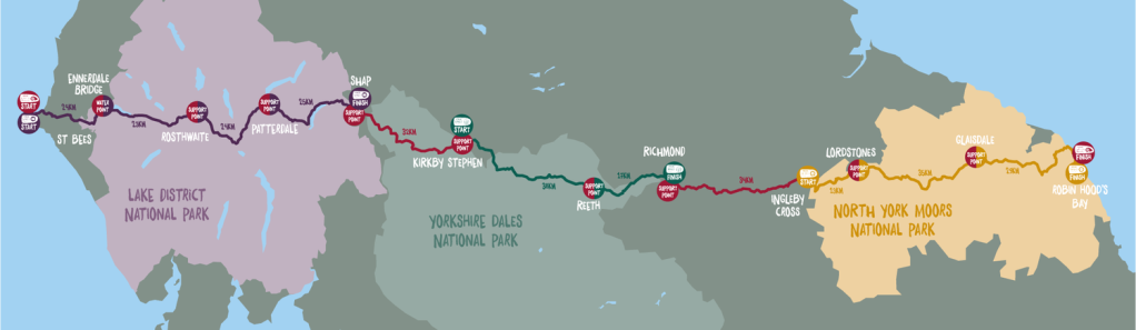
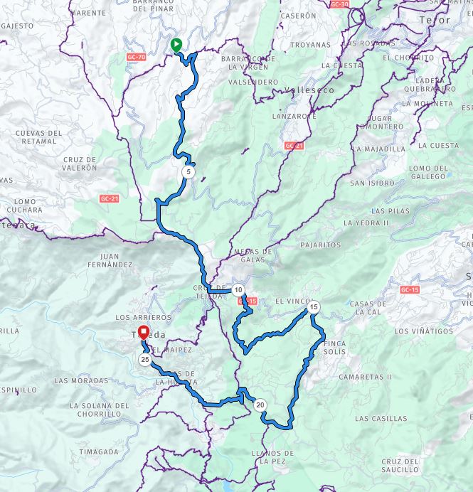
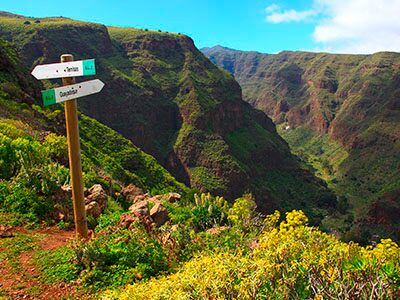
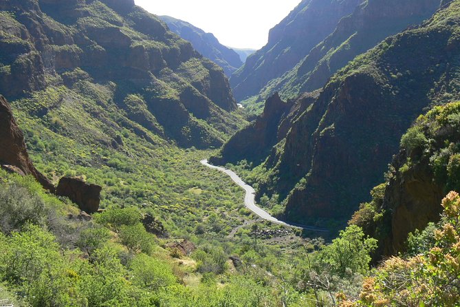
The route really is fantastic. It is currently in the process of being upgraded with more sign-posting and trail maintenance in preparation for its designation as an official national trail in England. The route goes through 3 English national parks : The Lake District, The Yorkshire Dales, and the North York Moors. I’ve always loved the Lake District. It’s one of my favourite areas in the world. But after a few Northern Traverses I’ve grown to really like some sections of the North York Moors as well.
The Northern Traverse Route, through 3 National Parks
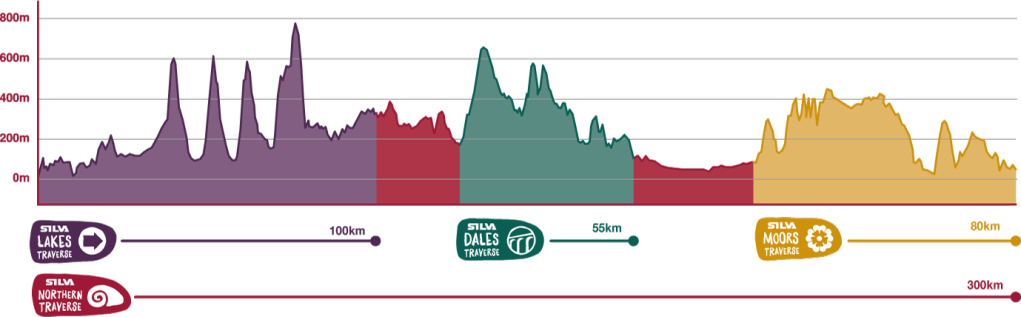
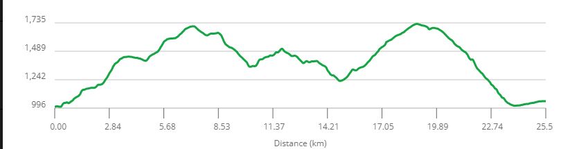
There’s 4 races happening over the course of the event. The Northern Traverse is the big one that covers the full coast to coast route. Each of the national parks has it’s own individual Traverse race as well (covering the relevant subsection of the Northern Traverse route).
Profiles of the 4 Traverse races.
My ambition for this race is to finish as fast as possible, hopefully to arrive at my accommodation booked for Monday evening in Robin Hood’s Bay. When I was younger and faster that was comfortably achieved. I was fast enough to win the first 2 editions of the race. But I’m older and slower now, and my finishing times are drifting out (and these days a top ten position would be a great result). With the storm, this could now be an overly-ambitious target. Time will tell.
To me it looks like there are two favourites to win the Northern Traverse. In the Female race Hannah Rickman looks like the top candidate. She has twice finished in second place in the full winter Spine (And got a lot closer to Claire Bannwarth this year). Lianne Van Dijk is travelling over from Ireland, having built up a great collection of results on the Irish mountain running scene. I’m hoping to see her competing towards the front of the field. Run247 have Edwina Sutton down as another one to watch, with good reason!
In the male race Mark Darbyshire looks like the obvious favourite. He’s got great speed over distance, and was the joint winner of the Lakes Traverse last year. I was hoping Paul Tierney, my fellow Corkonian, would give him a run for his money, but unfortunately he was telling me he won’t make the race due to injury. Run247 note a few other runners, such as myself (hah! Unless I’m the only survivor of a weather apocalypse!), and David Parish, a winner of the Cape Wrath Ultra. James Elson is a former British 24 hour international, so he could be a contender as well.
There are loads of names I don’t recognise in the start list. No doubt one or two will emerge and make a name for themselves by competing well. Everyone starts somewhere!
The race will be fully tracked, with James Thurlow’s Opentracking, the best in the business, on the job. The live tracking can be found here : https://live.opentracking.co.uk/northerntraverse2024/. The Northern Traverse is due to start at 8:30 a.m. on Saturday morning, the 6th of April, charging into the teeth of storm Kathleen!
We’re in the darkness of waiting for the return of the runners again after another burst of activity from Keith, covering the finish of loop 4 rush hour! We’ve been in record-breaking unprecedented territory for quite a while now, and that is going to continue. What a year! I thought I was lucky to be at Barkley last year to witness such an amazing year, but those lucky enough to be there this year are getting to witness an even bigger and more dramatic chunk of Barkley history.
To catch up with my last update, we’ve had a record 12 fun-run finishers. Maxime Gauduin finished loop 3 at 34:32, and while he was still in camp Tomo Ihara came in at 34:43. Both had time to make it out onto loop 4 and both did, with Tomo getting a quick turnaround and heading out at 35:04. Maxime however used every minute he had in camp (presumably he was right on the limit of sleep / energy deprivation) and headed out at 35:59:26, with 30 seconds or so to spare. So that gave a record 10 runners out on loop 4. It wasn’t looking good for Tomo and Maxime to make it around, given how tight they were on time, but it was a fantastic achievement to make it out at all!
Not long afterwards Thomas Dunkerbeck completed loop 3 at 36:15, getting a hard-earned fun run. There was then a long wait before Guillaume Calmettes, a many-time veteran of Laz’s races, came in at 39:53, with just minutes to spare to complete his fun run (again!). Given that he had missed a page on his first lap, and gone back out on course to get it, that was a hugely impressive achievement. That’s the kind of never-say-die attitude you need for Barkley success.
I woke up this morning and immediately checked Twitter/X (That’s the first time I’ve used that sentence), to see we were in the middle of the loop 4 finishing rush hour. Overnight Maxime had dropped out at the fire tower (very roughly about 1/3 of the way anti-clockwise), the only place on the course you could realistically find a human with a car to extract you. That’s where the photographers get the pictures of runners heading up and down rat-jaw.
Rat Jaw, from near the fire tower
The time limit to start loop 5 is 48 hours, but realistically you need to get out with a bit of a margin over that to complete the course by 60 hours. At this stage in the race everyone out there is operating with huge fatigue from all the climb and descent, the concentration of navigating, especially in darkness, and of course all done on little or no sleep. At 48 hours sleep deprivation is definitely going to be kicking in and ensuring that even the best athlete’s brains will be wandering all over the place!
And of course, for loop 5 we have a new factor in play… direction. The first runner out gets to choose whether to go clockwise or anti-clockwise. Each subsequent runner alternates. This is to try to ensure that everyone runs the last lap solo. But with 9 runners still “alive” that might not work so effectively this year! Last year I think there was universal agreement that CW was hugely preferable to ACW. Most of us felt it was significantly more difficult ACW. I doubt the changes this year will have altered that too much (Possibly they could have re-enforced it).
The campground is the last “safe” opportunity to grab some sleep too. Safe in the sense that you have a helper to wake you up and ensure that you don’t oversleep (remember, the only electronic assistance that anyone is carrying is the race-issued watch. And that’s not exactly bulletproof reliable for setting alarms).
And so the final “interloopal” drama began with Ihor and John Kelly arriving in together at 45:46. That’s a few minutes faster than John had managed last year, despite the additional difficulty of this year’s course. Last year John wanted to be absolutely sure to get to be out first, so as to choose CW for himself. So it would be interesting to see if he would repeat that.
But it was Ihor who turned around the fastest. He had a super-fast turnaround to exit at 46:06. He chose clockwise, unsurprisingly. He is now looking very good indeed for a finish, with a solid margin over the cut-offs. But this is the Barkley, you never know! You can lose that margin time much more easily than the effort it took to establish it.
Next to arrive were Greig Hamilton and Damian Hall. at 46:15 and 46:16. They were probably running together out there. Damian was more than an hour faster than last year. More significantly both of them were ahead of Karel Sabbe’s 46:36 from last year (which was good enough for Karel to finish, but with the tightest margin to the cut-off of any finisher). Only a few minutes later at 46:19 Jared Campbell arrived in. Jared is setting himself up nicely to be the first person to finish the Barkley 4 times, 8 years after his last finish.
Keith’s next updates gave us the departures from camp onto loop 5. We didn’t get any start times but we can infer that they were all before 46:29. JK was first out on the ACW loop. He must be feeling relaxed about direction this year. Damian was next, and as a result gets to go CW. I’m glad to see that. I’m really rooting for Damian, so I’m glad he gets the nominally better direction. And then Grieg headed out ACW. I’ve no idea how close these departures were, but it’s quite possible that Grieg and JK could be running together. There could be fire tower pictures arriving at some point today which will give us an indication of that.
Shortly afterwards came the tweet that so many people have been waiting for. Jasmin arrived in at 46:29. She is already smashing records here and putting in an unprecedented performance. She is the first female to complete 4 laps. (Earlier in the race she became the first female to complete 3 fun runs). But she won’t be thinking about that at all. She has one primary target here, which is to become a Barkley finisher.
The next tweet from Keith brought us the news of more departures. Jasmin had a much faster turnaround than Jared, as she left first, and got to head CW. Again, I’m really glad to hear that. Like most of the watching world at this point, I’m really rooting for Jasmin here. Her lap 4 finish time and lap 5 start look to be within the coldly realistic times that give her a solid chance to complete the race. And heading CW adds to that.
Jared’s departure was signalled in the same tweet, so was probably at roughly the same time. He’ll be heading ACW, obviously. He’s also within the realistic timeframe for a finish. So we now have 6 runners out on loop 5 with a genuine realistic chance to finish.
Jasmin grabs a power nap before departing for loop 5
Next came the news that Tomo and Albert had taken quitter’s road to pull out of the race from loop 4. Two fantastic performances to get that far. They were always up against time-wise from their start of loop 4, so it wasn’t too surprising to hear this.
Keith’s next tweet was “The conversation in camp right now is whether back to the future guy could give himself extra time in the #BM100 and how exactly that might work.”. That’s funny!
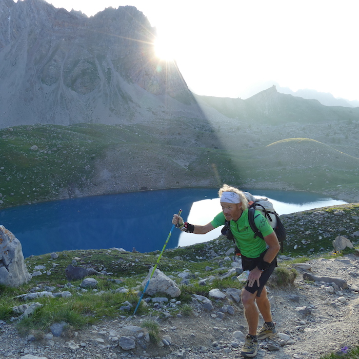
“Doc” Sebastian, somewhere in the Alps
But a little drama rather than comedy was to come for Doc, as Keith tweeted that Sebastian was finishing loop 4 on the wrong route, so needed to back out and come in again on the correct route. He finished at 47:45. Yeah, he could definitely use a DeLorean right now! Only 15 minutes to turn around. But he did it, and got out onto loop 5 with 3 minutes to spare over the cut-off. Being realistic you’d have to assess that he has only a very slim chance of making it. But he is still in the fight, and is out on loop 5. That’s damned impressive stuff for a V50.
So now we have a record 7 runners out on the course, with a coldly realistic chance of 6 of them making it. It should be daylight again by now, so that will help keep everyone awake. All has gone quiet on the communications front again. We all now wait patiently for the big excitement of this evening rush hour of triumph and glory.
The camp will be buzzing for the day, and as the time approaches for the expected arrival of the runners, the excitement will be through the roof. It was a privilege to be there last year for 3 finishers (as well as to spend some quality “analysis” time with Damian after he pulled out on loop 5). I’m going to leave you with this great video by Chloe Reed that she filmed of her experience supporting her Dad Billy, and myself. She really captured the finish-line atmosphere very well indeed.
It’s been very quiet for most of the day. The runners have been “out there” battling the course. And we have no tracking or communications with them. To be successful at the Barkley it definitely helps to be the kind of mountain runner who relishes being out in the wilderness, completely out of contact, and totally reliant on your own skills and ability. The race is currently narrowing down to some of the best exponents of these characteristics.
But after a quiet day, the last hour or two has seen a rush of tweets from Keith, as the lead runners come in from loop 3. The campgrounds will have been a hive of excitement and activity, but in another few hours it will all become more chilled and relaxed again, with all the activity taking place out there on the course, beyond our view.
I was quite surprised to see Ihor Verys arrive in first, on his own. The surprise is because he is a Barkley virgin. Clearly his nav is excellent, and his confidence is rock solid to deliberately lead the field on his own. It’s great to see a Ukrainian runner doing so well.
To be allowed onto loop 4 runners must depart before 36 hours (race time). There is another 3 hours allowed for runners to arrive in with 3 laps to complete a fun run, but after 36 hours they will not be allowed back out on the course.
Ihor finished at 31:31, so he had a big enough margin to have a relatively relaxed “interloopal” stop, do his admin, catch whatever sleep he might decide to take, and head back out. But if a runner is feeling really good then they can get by on the minimum of admin, and head back out soon enough. Anything under 20 minutes is pretty fast. You can get a good indication of the physical and mental state of the runners from their turnaround time when they are not under cut-off pressure. Notably, Ihor’s 3-lap time was the fastest in 8 years. And that’s on a harder course than last year (which had 3 finishers). That’s very impressive indeed.
5 minutes later John Kelly and Damian Hall arrived and completed loop 3. It looks like they have been running together. They’re close enough to ihor in race time as makes no difference from the point of view of finishing. It sounds from the descriptions that all 3 are in remarkably good shape.
The next action was Ihor leaving at 31:46. So that was a fast turnaround. Again, he must be full of confidence to leave the other 2 behind in camp and launch out into the course completely solo at the head of the race. He was fast, but so were his pursuers! JK left at 36:48, and Damian left at 36:50. That’s all very fast and very close. I’d guess that Damian will try to join with John again (Personally I definitely think it’s more fun that way). Last year John was more inclined to run off solo, given the chance. We’ll see what happens. But they’re all close enough that there is plenty of scope for overtaking or teaming up, depending on how they’re feeling on loop 4.
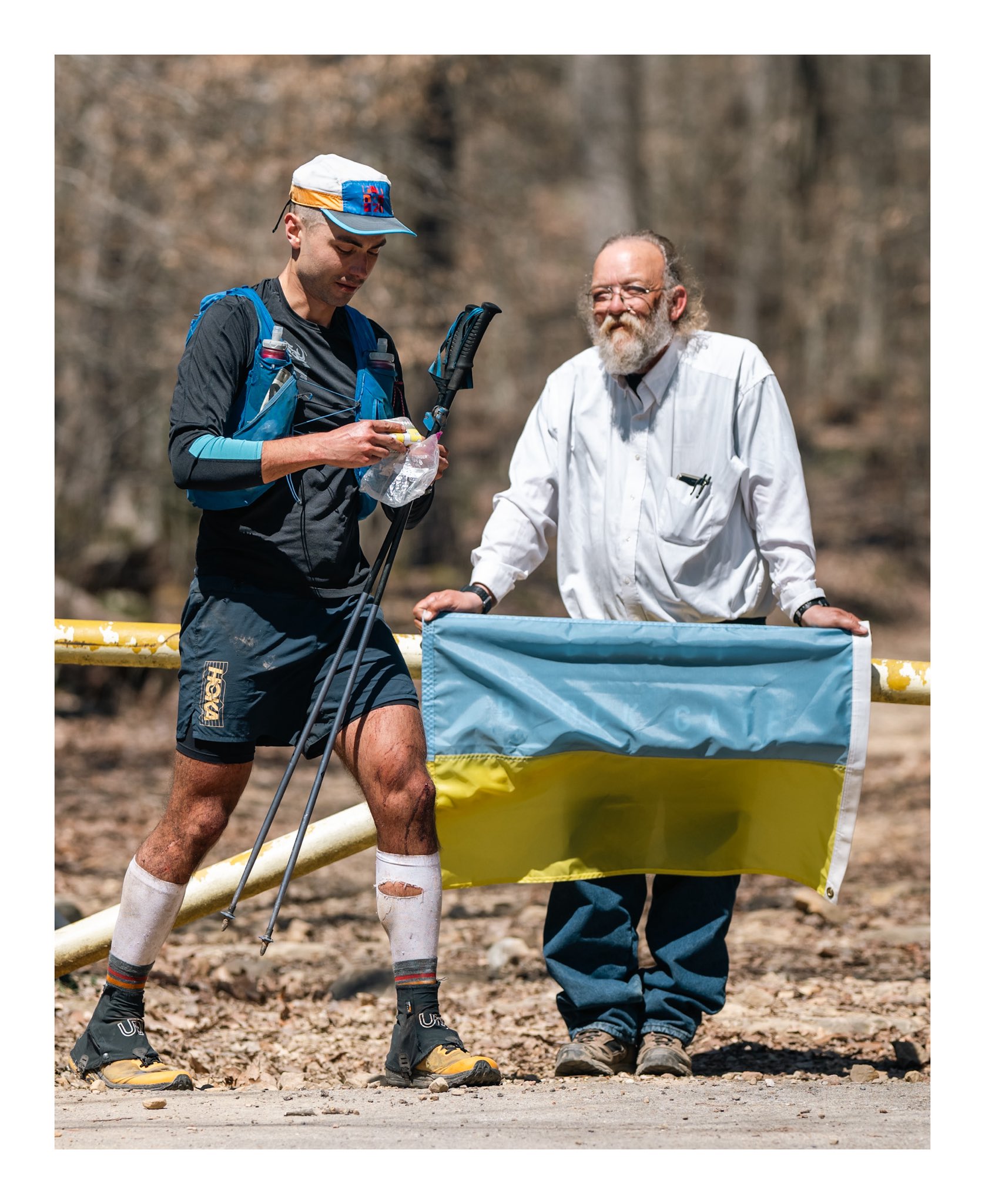
A Howie Stern picture of Ihor heading out for loop 4. Laz has gone to the bother of retrieving the flag to wave him out.
Another potential driver of fast turnarounds is daylight. They’ll prefer to run as much of the course as possible in daylight as possible. It’s much easier to navigate under sunlight than mere torchlight. The next turnaround for the leaders will be in the middle of the night, if they can make it!
The “missing” runner from the lead pack at the start of loop 3 at this point was Jasmin. Still a long way off from being in any way worrying, but lots of fingers were definitely being crossed now.
However the next runner in at 32:12 was Greig Hamilton, from New Zealand. This is his 3rd attempt at the Barkley. Despite the course getting harder every year, his fun-runs are getting faster. And then, only 3 minutes later, Jasmin arrived in to camp to complete her 3rd fun-run. Her 32:15 time is the fastest-ever female fun-run. Yet again she is setting records. According to Keith she was smiling and looking good. She seems to be running much stronger than last year.
5 minutes later Jared Campbell (nondescript guy!) arrived. There were now 3 runners in camp again. Jared is definitely up for it this year. He is already the man with the most Barkley finishes in history. It’ll be quite a gap between #3 and #4 if he can pull this off! Last year I was very intimidated to go up and say hello to him in camp after we were finished (because he is such a legendary runner), but he turned out to be a thoroughly nice guy (as did everyone there).
Jasmin departed at 32:27. Another very fast turnaround. It’s definitely getting exciting now. The prospects of Jasmin becoming the first female to finish the Barkley are looking stronger than ever. If that happens, it’s going to be massive! The media frenzy could reach out into the mainstream media, not just the ultra world.
Grieg and Jared departed within a minute of each other at 32:43. It looks likely they’ll be running together for a while. Grieg had the slowest turnaround of the leaders, but it was still fast enough! Back to being an empty campsite, in terms of interloopal runners.
But that didn’t last too long in the rush hour. Next up to arrive in was Sebastien Raichon at 32:57. Still an excellent time for loop 3. He was the first runner to have the campground to himself (in terms of runners, there’ll be plenty of dropped runners and crew hanging around enjoying being part of the event). And the next communication from Keith was that he departed at 33:16. Yet another fast turnaround.
5 minutes later at 33:22 we had a near repeat cycle with Albert Herrero. That was an hour slower than last year. Given the course is longer and harder, that probably means he was running a similar pace and effort overall. Hopefully he can keep it going through a 4th loop (and beyond) this year.
So right now at the time of writing 8 runners are out on loop 4. According to Keith, that is a new record. In my opinion all these runners have the ability to get 5 loops. They certainly all have a big enough time margin to complete loop 4 and make it out onto loop 5. But this is the Barkley. There’s going to be more drama! And heading into the second night is going to put everyone into sleep deprivation stress.
There are 4 more runners still on loop 3. They all still have enough time to get out onto loop 4, which would be a massive accomplishment. It’ll be particularly impressive if Guiluame can pull that off, given his earlier missing page incident. But that’s very unlikely, given he was up against the fun-run time limit leaving for loop 3. They’re all looking less likely to make a finish, but again, this is Barkley. You just never know! Maxime has lost time to the other runners in loop 3 (he finished loop 2 ahead of Albert), so it looks like he is slowing.
So we’ll probably get one more burst of loop 3 finishing excitement, before once again heading into a couple of hours of communications emptiness. The long dark tea time of the soul, as Douglas Adams might have described it, for us onlookers, and even darker for the runners battling night 2.
It’s amazing how compelling it is to watch a race via a one-man Twitter feed, and a collection of rumours, all summarised into an online spreadsheet. (It reminds me of Gary Linker saying that the best place to watch Wimbledon play football was on Ceefax… Only older English soccer followers will get that one!). But here we are, avidly following along! And in my case finding it extremely compelling.
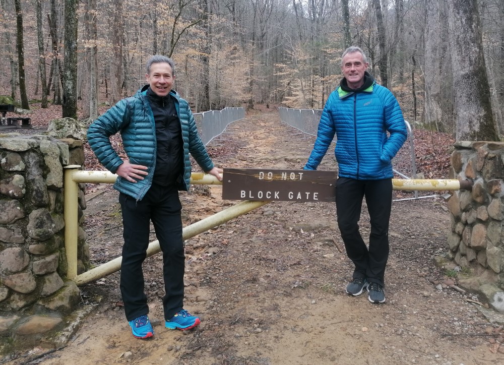
I’d rather be here, Blocking a yellow gate with Billy Reed!
I was tempted to write an update post before heading off to sleep, but I was already later than I wanted to be having got distracted by the race. So I thought I’d try to get a post after all the overnight (for here in GMT land) activities. And of course, it’s the Barkley, so plenty has happened!
One of the most useful things to have happened is that Keith has decided to have mercy on us all and start using people’s real names. So now the virtual fog has lifted a bit.
Sadly Joe McConaughy became an early victim of this year’s race. Apparently, he injured his ankle early on loop 2. Joe is as tough as they come, so it must have been a nasty injury. That’s the first genuine possible finisher to exit the race (Joe is also possibly the fastest racer to take part in the Barkley. His range is phenomenal. His mile PB is a few seconds over 4 minutes, which is phenomenal for someone who held the FKT for the Appalachian trail).
Yesterday one runner managed to miss a page on his first loop (not that unusual), but managed to go back out on the course, find the book, and return with the complete set of pages within the time allowed, and got back out onto loop 2. Now that’s very unusual! Amazing mental resilience to do that. Rumour initially was that it was Harvey Lewis, but the spreadsheet is currently showing Guillaume Calmettes as being the runner (Guillaume’s been out on the course enough times… it’s surprising he missed it in the first place). Plenty of drama there. (Just before posting this, I read that Guillaume finished loop 2, turned around fairly quickly, and made it out onto loop 3 with about 3 minutes to spare… go Guillaume!)
22 runners seemed to have made it around loop 1 under the cut-off, and back out onto loop 2. That’s a high number, but I’m actually surprised it wasn’t higher given the ideal weather. It sounds like there were a lot of people making big navigational mistakes. You need to have at least one excellent navigator in your groupetto to get around a Barkley loop. And to finish you need to be able to do it for yourself by the 5th loop. It’s not easy.
The loop times for the leaders on loop 1 weren’t super-fast. I think the new climb added this year must have had a definite impact on the difficulty. That’s going to add up over 5 laps, so the chances of having a large number of finishers are probably pretty low, despite the near-optimal weather conditions.
The first loop 2 finishers were John Kelly, Jasmin Paris, Damian Hall, Sebastien Raichon, and Ihor Verys (All name-checked in my first post!), in about 19.5 hours. All of that group can finish. What a stellar bunch. It’s particularly exciting to see Jasmin running so well at the front. She’s clearly in very good running form. She seems to be running more strongly than last year. Fingers crossed, but right now she’s in perfect position to be the first female finisher of the Barkley. That will be huge if/when it happens.
If Sebastien finishes I think he would be the oldest-ever finisher. I’m not 100% sure of that. At most there is only one ever finisher over 50, but I might be over-estimating that. I can’t remember where I found the age-stats for finishers when I was looking it up before my run last year (just in case!). He has more speed endurance than most elite-level younger runners over this kind of multi-day distance, so it’s definitely “on” right now.
It’s great to see 3 Spine race winners in that lead group too. Needless to say I’m rooting for all of them. They’re all super people as well as being phenomenal athletes.
The most surprising tapping out so far is definitely Aurelien Sanchez, last year’s winner. It just goes to show how everything must be right to get a finish. He was in by far the best shape of the 3 finishers at the finish line last year. So something must have been “off” with him. He’s still a legend though!
Albert Herrero is also back out on loop 3, having also paced well for the first 2 loops. He’s a bit behind the lead group. But he’s the best navigator on paper in the race (A former regaining world champion), so will be well able to handle himself once he can keep his speed high enough. A fun run looks highly likely, and hopefully he’ll make it all the way to loop 5. It won’t be navigation that takes him out!
I was delighted to see that an old adventure racing teammate of mine, Mark Latanzi, was in the race. Unfortunately it is “was” though, as he tapped with one lap successfully completed. He’ll have enjoyed that immensely!
Greig Hamilton, Jared Campbell, and Maxime Gauduin are all also out on loop 3. That’s a lot of very capable runners still “out there” and moving well, without any weather “gotchas” to take them out. There’s still a lot to watch and keep track of.
Also news in that Harvey Lewis was amongst a group of 4 that were tapped out from loop 2. It just goes to show how difficult the Barkley is, and how broad a skillset is required to be successful there. Harvey is after all the world record holder at Backyard ultras (and an elite level 24-hour runner too). And the Backyard is possibly the second hardest race format out there, I reckon. But Barkley really is something else!
I came across an interesting image that I found whilst following the race :
This was posted by David Blank. His annotations are:
1. Meatgrinder into hill-pocalypse, 2 Little Hell ,3. Rat Jaw, 4 Big hell
I’ll make no comment, beyond saying it is definitely an interesting image 🙂
The Barkley Marathons… it all kicked off again a few hours ago. And this year I can talk about it since I’m not in it. As ever information about the race is hard to find. The primary source of information is the wonderfully sarcastic Keith Dunn (At last year’s race, even his hairstyle was sarcastic). The only good reason to be on Twitter/X is to follow Keith’s tweets from Frozen Head (@keithdunn, if you want to find him.
They’ve got the names of 23 runners (out of 40 entrants) accounted for so far, which is good going.
The race had a 5:17 start time this year. That’s not too bad. Enough time for a reasonable night’s sleep. The really big variable in any year is the weather though. I was looking up the sites I used to predict the weather last year (which were very accurate) and it looks like they are going to get even better weather than last year. A similar lack of rain, but without the freezing temperatures. Given those facts, and the usual strength of the field, I reckon we’ll see finishers again this year.
As I said, it’s quite a line-up, as you’d expect. The 2 people I most expected to see return, Damian Hall and Jasmin Paris are both back. I’m very much hoping and expecting that they will do better than last year. And last year they did very well indeed, with Damian starting a 5th lap, and Jasmin getting well into her 4th lap. It would be awesome to see a finish from either of them. Jasmin has all the qualities needed to become the first female finisher. That would be particularly awesome.
A Barkley first-timer who is particularly interesting is Sebastion Raichon. He is a V50 French runner who has won the Tour De Glaciers in dominant style, twice. He could easily be a finisher on his first attempt. He has said that he enjoys orienteering, so it would seem he has all the skills and attributes required to be a finisher.
There are also several returning finishers. Two of last year’s finishers are back, John Kelly and Aurelien Sanchez. Needless to say, they are both obvious candidates to finish again. 3 times Finsher Jared Campbell is also back. He did pretty well last year, so the fact that he is back again might mean that he is motivated to push on and try for his 4th finish. In any case, having 3 past finishers in the field is great for all the other runners, as there are people who absolutely know what they are doing “out there” to run with/near.
There are a few other old friends of mine running who are also definite candidates to go a long way here. Albert Herror is a Spanish runner/orienteer who is a great ultrarunner and world-class navigator. This will be his 3rd attempt, and he is getting better with each attempt. He should be able to do that hard part of navigating the course without too many mistakes better than most. Joe McConaughy (Stringbean) is also back. He had a great first-time run last year, getting a solid fun run (3 laps), and I know he learned tons. As a past record holder of multiple long-distance FKTs (including the Appalachian Trail), he’s got the ability to do this. I’ll be rooting big time for them.
And then there are a few world-class Backyard runners in the field too. World record holder Harvey Lewis is the one runner everyone knew would definitely be in the race this year. Ihor Verys wasn’t too far behind Harvey at Big’s. That must have helped get him into the race here. Obviously, they’ve got the stamina and resilience to get around. It’ll be interesting to see if they have all the other skills required to get a finish.
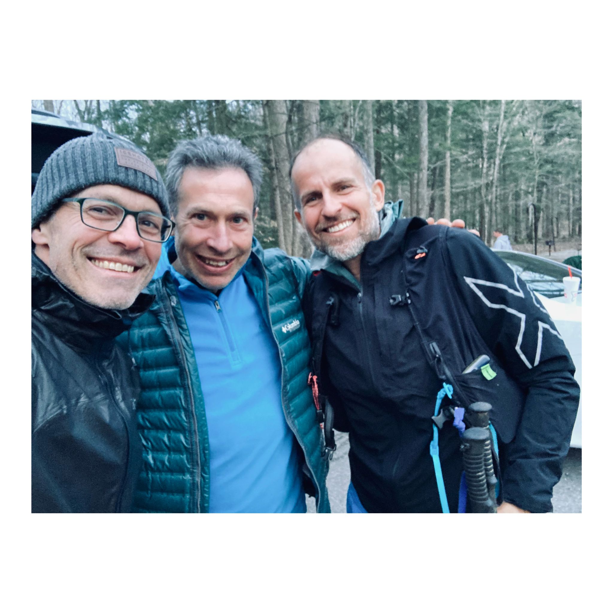
Hanging around a forest car park last year with Legends, Harvey and Luca
At the time of writing this post, there are more than 12 runners in with a loop 1 time 9:16 or better. With the weather so good it looks like we’ll see a lot of fun run finishes this year at minimum. Keith Dunn is being as cryptic as ever, so it’s hard to work out who is actually getting these laps, but the spreadsheet is working out one or two of them (I reckon Aurelian and Sebastian are the two French runners in 8:45).
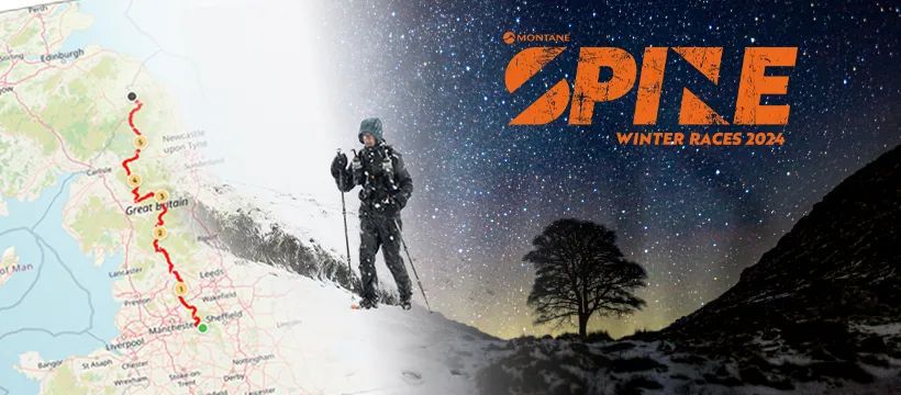
Oh boy! What a race we have in store. The line-up for this year’s Spine race is awesome. There are only one or two past winners who will not be on the start line. Pavel, Damian, John Kelly, Eugeni and myself will all be there. That’s 9 previous wins in that collection. The fastest Spiner in history is a notable absentee. But Jasmin’s husband is listed to start, so I’d guess we’ll see her at some stage. Tom Hollins is lined up to compete in the Challenger North. He must be getting soft in his old age 🙂
There are several more runners who are well capable of winning or getting on the podium to add to the pile! Kim Collision, Jack Scott (second last year, with one of the all time fastest runs), Rory Harris, James Leavesley, Dougie Zinis, Mark Potts are all runners who will be at the top end of the field.
With such a massive deep field this year is much harder than usual to predict what is likely to happen. With so many fast runners it’s very likely that the pace will be extremely fast from the start. Whoever is going to win this race will have to push themselves right to their limits without crossing over them. That’s always a tricky balancing act, particularly in a race this long. As a result I think we’re likely to see a very exciting dynamic race, with lots of back and forth, and probably a few dramatic exits.
If I was pushed I’d say that the most likely ones to win would be Damian, John, or Jack, with Kim only slightly behind those 3. But they are all so capable that it’s likely that form will be the separator. And nobody will have enough knowledge to know which of those will have the best form in the race. That just makes it all the more exciting. Eugeni has the speed to mix in with those runners too. But he is so unpredictable that it just seems a little less likely he would emerge in front of all of them
One thing I can predict with certainty is I will not be mixing it in with those runners at the front of the field. Even at my best I don’t think I would have been able to catch those 4 at their best. But I’m now 55, and I have been feeling myself losing speed with each passing year for a few years now. I’ve still got all the other tools in the set to compete to win, but without speed that will be nowhere near enough.
I made the cover picture this year, if nothing else!
So I’ll just be heading out to enjoy the race, compete at my own level (try to compete in my age category, even though there are no “official” age categories or prizes), enjoy the spectacle of the race from an inside viewpoint, and make it to the finish with as little pain and suffering as I can.
The weather forecast is looking as good as you could get for the Spine. It’s quite possible we could have an almost completely dry race, with just the occasional bit of precipitation. With the temperatures forecast to be quite low, the precipitation could well be in the form of snow. All that is about the most straightforward conditions we could hope for. Perhaps a little too straightforward from a Spine tradition point of view. Time will tell. That’ll be another factor adding to a potentially very fast winning time.
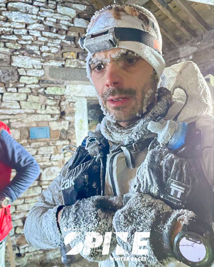
My old friend Jo, from Serbia, showing the effects of last year’s Spine weather at Greg’s Hut
The female race also has a collection of strong runners likely to be competing for the podium. Claire Bannwarth is returning to defend her title. I was chatting with her after her very impressive win at the 360 Challenge in Gran Canaria,and she was saying she was hoping to get the full Spine experience of having to deal with being battered by British winter storms. I reckon she has to be the favourite to win again.
Anna Troup is another past Spine winner who will be at the front of the field if she is in good form. Hopefully she can race fully back to her best, free of injuries that have caused her problems.
Then there is Nicky Spinks (My Barkley running partner). Nicky has a long history of excellent performances in tough events. She recently won the Cheviot Goat, which seems to indicate that she will be in good shape for the Spine (The Spine finishes on the Cheviots). Even though its her first Spine she should be able to run it like a veteran.
Elaine Blisson is back, having had a great race last year. She’ll likely be competing for a podium spot as well.
In both categories I’ve likely missed a few runners who will emerge as contenders as the race progresses. There are plenty of names entered who I am completely unfamiliar with.
It’s great to see a good Irish contingent taking Part. Irene Finnegan was going well last year when injury took her out. She’s back to put that to right. My old friend (in every sense!) Brian Hutchinson will also be competing in the full Spine this year. He won the Northern Challenge last year. I’d be very happy to run with Brain out there if our paces align. I’ve known Brian since my college days! Neither of us were runners back then. It’s funny how life creates these loops.
I barely mentioned the other Spine races which will also be happening. There are quite a few notable runners (including another interesting batch of Irish runners) across those races. They should also make for good dot watching. The Northern Challenge looks particularly interesting.
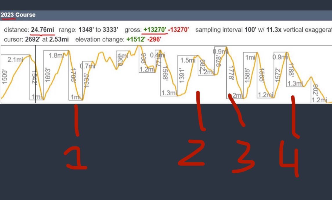
As ever, one of the great things about the Spine is that all of us runners are primarily dots on the live tracker! The live tracking is always superb. The races can all be tracked at https://live.opentracking.co.uk/spinerace24/. The Spine race itself is scheduled to start at 8a.m. on Sunday Morning (January 14th).
It gets easier to pack for these races with experience. Mostly I will be using gear that has worked well for me over the years in this race. There’s one or two new bits on the go though. I’ll be using my Garmin Epix watch as my main navigation device. I’ll also be using two pairs of Columbia Escape Thrive Endure waterproof shoes. These have a huge amount of cushioning in them, and strike me as excellent shoes for a race like the Spine.
So over 400km with over 10000m of climbing, in whatever weather the British winter throws at us, lies ahead, as I make my way up the Pennines (The Spine of England) across the border to finish in Scotland. I’ll be at least 4 days out there. Even with all the experience I have with this race, it is still going to be an adventure which will test me all the way!
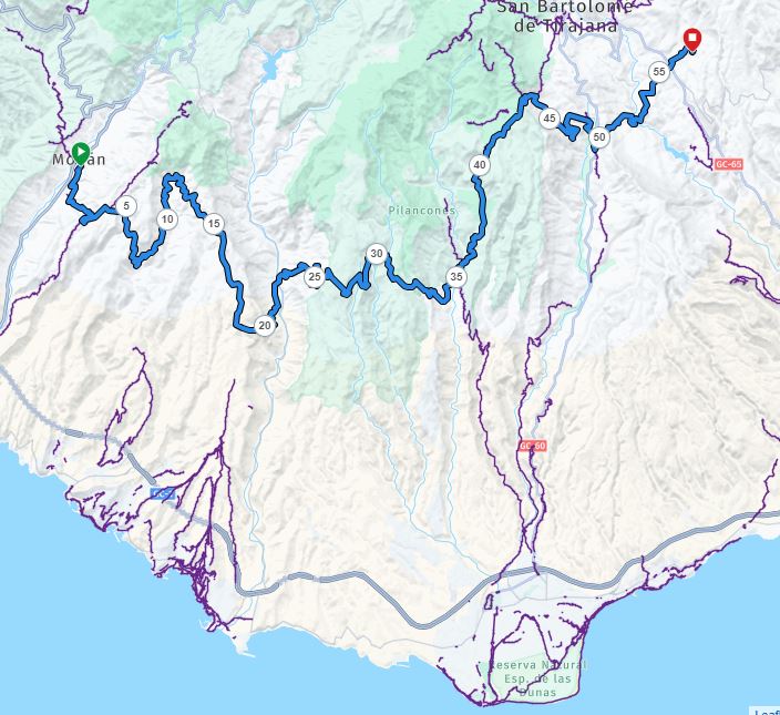
Even though I wasn’t planning on sleeping in Fontanales, the last Life Base, I was still going to take as much time as I needed. The last leg had gone as well as I could possibly have hoped for. It now looked feasible to finish by this evening (Saturday). I had been trying to work out in earlier legs how I would manage with my hotel room booked for Saturday night if I didn’t finish until an ungodly hour on Saturday or even Sunday morning.
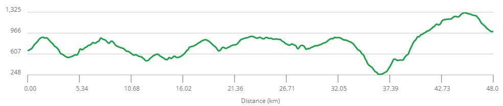
I assumed that the next and final leg would run similarly to the leg that brought me here, rather than the much more difficult and slow-running earlier legs. But this was also by far the shortest leg at about 26km or so. So even if it ran slowly in parts I reckoned I would still make it in before midnight at worst.
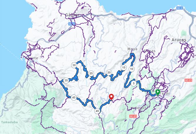
Fontanales to Tajeda Route
As usual, I tried to take on board as much liquid as I could here, and gave myself the time to fill myself up as much as I could comfortably manage. I also had a little bit of real food to eat, in the form of chicken and potatoes. One good overlap between the Canaries and Ireland is the elevated status of potatoes! There was another mandatory kit inspection here, which was good to see. It’s definitely preferable to see races enforce their rules.
Fontanales to Tajeda profile
At the same time, I didn’t want to needlessly burn up time here. I knew I had only recently overtaken one runner and had seen him behind me not that long ago (in multi-day racing terms). It would be great to get out before he arrived in. I also wanted to get as much climbing done as possible before the heat of the middle of the day. I reckoned it was still only around 8 or 9 in the morning (My watch was charging whilst I was stopped here, so I didn’t bother checking).
As usual, I was cheered out of the Aid Station by the staff. There was still no sign of my tail runner arriving in. I would say I was at least half an hour in the aid station, so I must have created quite a gap since the last time I saw him behind me. Maybe he had stopped for another rest on the trail. I started to get myself going, marching uphill on the road out of the aid station.
But I soon came to a halt. Something was irritating one of my feet within my socks (I had changed to new socks since I had them available). So for once I took immediate action and stopped to take that shoe and sock off and remove the irritant (a small piece of plastic… they were new socks!). After a few minutes I was off again (getting up and down was a challenge at this stage of the race), with still no sign of my tail runner arriving in.
A short steep road climb took me out of the village, and soon I was back onto lovely running trails. This was a continuation of the lovely grassy landscape I had encountered coming into the aid station. It looked absolutely beautiful in the morning sunshine. Like a sunny warm version of some of the nicer parts of Ireland in some ways. I knew this stage was heading for the centre of the Island, so there would be plenty of climbing to get there. And indeed this stage started with lots of uphill marching. At least there were no issues with the terrain!
I was much more confident of having plenty of liquid for this, the shortest stage of the race, so I knew I could “sip at will”, and not worry about drinking too fast. The heat wasn’t on full power yet anyway. It was that good time of the day with full daylight but without the intense heat. I remembered instructions to be sure to close a gate somewhere on this route. I quickly came across a gate and made sure to close. To my surprise, this was just the first of 5 or 6 gates on the track. Unually there was plenty of livestock around here. Lots of sheep grazing on the grass. Quite a contrast to the desert landscape of the southern side of the island.
I was leaving the town, and the outlying occasional farmhouses behind and heading into the more isolated hills. About half an hour in I checked on my watch to see which of the many parallel tracks I should take to contour around the side of the hill. The answer was “none of them”, as I had begun blindly following the trails off-course. I returned to the ridge centerline to keep heading uphill on what was a much more rarely used track.
A series of tricky navigation calls followed for the next 15 or 20 minutes. The indicated route seemed to go through almost impassable vegetation. In the end, after much back and forth trying to find the exact route I made a decision to just go around it and navigate back onto the indicated track on the other (higher) side. That all seemed to burn through about half an hour to make no more than a few hundred meters of progress. It was frustrating, but I was glad to see that there was still no one catching up behind.
A few more precise bits of navigation brought me through a fence where the hill topped out, and onto a relatively flat fireroad. I could see cars parked on a road in the distance, so reckoned this trail would take me there. After the frustratingly slow progress to get here, I was now able to move a little faster at my slow jogging pace on the flatter ground. This was also the beginning of a forested area, so there was some nice shelter from the sun. It was very pleasant running terrain.
The trail did indeed reach a carpark just off a road, where a few people were waiting and cheering. These were race volunteers. One of them checked I was OK, and then ran behind and beside me for a while (more walking for him and running for me). as I headed off down the gently descending road for a few hundred meters.
The easy road descending didn’t last, and I said my “see you later” to the volunteers as I took a right turn and headed onto a trail going directly up another ridgeline. I could now recognise some of the features of the landscape ahead. I knew I was heading up towards the ridgeline between Artenara and Cruz Tajeda. We had run down that ridgeline last year. But it was still a kilometre or two of climbing to get there.
The route broke out of the woods quite quickly, and it was a lovely-looking landscape ahead. I could also see one or two walkers heading towards me on the trail up ahead. The slope was at an angle where I could just about productively jog, which I did, with walking intervals as it occasionally became steeper here and there. Without the trees I could feel the heat now, so as usual I had to ensure to keep my effort levels well moderated.
A few hundred meters later it was back into forest again, which made for nicer running trails, and some shelter from the direct sunlight. It was definitely nice to make progress, and feel like I was making progress! I passed a few more people wearing race t-shirts in this section of forest, with much encouragement from them.
A short flat section of road followed, before a shape left turn onto a forest road heading up towards the main ridgeline. This was a bit steeper, but I still tried to jog up wherever I could. There were a few tourists around here walking on the trails. I was glad to see that I still just had about enough speed to catch and overtake them.
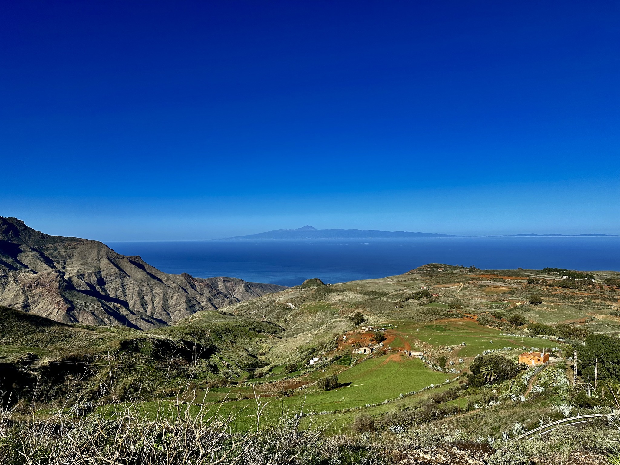
After a kilometre or so this trail merged into the trail which roughly follows along the ridgeline. I immediately recognised it from last year’s race. This was a lovely runnable section. It headed gently downhill for a few minutes before popping me out onto a carpark and a very short section of road right on the ridgeline. There were spectacular views from here out over Tejeda and Roque Bentayga area.
Heading away from the road and forest, back to desert trails. Photo by Ian Corless
It was quickly back off-road onto a track contouring around the left (Tejeda) side of the ridgeline. There was no more tree cover, and the landscape was back to its more familiar dusty desert style. I could see someone ahead on the track, who looked like he might be a photographer. Sure enough, it was Ian Corless. He jokingly greeted me as my private race photographer (there were so few runners left in the race that we were few and far between, so Ian had to plan carefully to get himself in position to get any pictures of the competitors). We had a few minutes of conversation as he zipped around me taking pictures from multiple angles.
Heading for Cruz Tajeda, Photo by Ian Corless
A couple of hundred meters of flat contouring was followed by a few hundred meters of sharper descending. I remembered it being a brutal climb going in the opposite direction in last year’s race. The trail descended down and popped out onto the road at Cruz Tejeda. This was another world. It was the middle of the day, and there were a lot of tourists there, particularly around the row of stalls selling various mementoes on the opposite side of the road to the hotel here.
Happy to see another Ian! Photo by Ian Corless
I got a good cheer from a few people who seemed to know about the race. There were one or two people who were probably more directly involved in the race, and they again checked that all was good with me, and pointed out that one of the stalls sold drinks. My liquid supplies were good, and I reckoned I had plenty to get me to the finish, but I wasn’t going to pass the opportunity to get a refreshing cold drink.
I went into the shop and used my Garmin watch to buy a can of Fanta and an ice cream. I took a few minutes to stop and sit in the shade, making sure to fully appreciate the cool treats. But it was quickly back to the reality of finishing out this race. I soon left the hubbub of Cruz Tejeda behind, heading left off the road and onto a trail heading downhill off the ridgeline. I recognised the valley ahead. It was the valley that the bus from San Mateo to Tajeda travelled getting me to and from Tejeda before and after the races.
I was making good progress again, as the trail quality was fine, I was nicely refreshed and was heading downhill. After 5 or 10 minutes I could see that I was approaching a lower section of the road. But just before the trail popped out onto the road the route took a right turn and skirted along a branch section of trail just above the road.
This is where the trail quality went to hell in a handcart. It had all been too easy to here! This trail seemed like nobody had used it in decades. I was back to thrashing through the vegetation encroaching all over the trail. Within about a minute I managed to trip and crash to the ground in a heap. I allowed myself a nice amount of time to slowly get back up and get going again.
This was also the end of the descending, so it was back to contouring and climbing. A few minutes later I had another bit of back and forth trying to figure out the correct line to take, but only lost a minute or two. Even with a GPS navigation can be ridiculously tricky on this race. There is no way you could find the paths just using a map and compass, particularly at night. It was tricky enough right now in the middle of the day with a high-resolution GPS watch.
I battled on for what seemed like an age. The trail quality gradually improved from atrocious to “alright” as it climbed up the side of a big river valley (without any sign of a river, as ever). As a result, my real speed was improving little by little again. I was hoping there wouldn’t be too much more of the bushywhacky trails.
As the trail headed towards a road higher up the valley it started turning across the valley more, so that it would never quite reach the road. It was also getting flatter as a result. There were some sections of a hundred meters here and there running along the broken concrete tops of old water canals. These were actually runnable, even though they took a lot of care to not fall off the wrong side!
I could see a big house ahead as the trail arced around the valley. Just before reaching the house the route branched right to head above the house and intersected the dirt road leading to it. In my heart, I wanted the route to turn uphill and hit the road to take me up towards the top of the island. But of course, such an easy option was not to be. I turned left and headed down the dirt road away from the road above.
At least this was descending, and I was able to run at a reasonably steady pace for a few minutes. The dirt road headed down past one or two more remote farmhouses before reaching the centre of the valley. remarkable there was actually a river in this river valley. More like a small stream, to be accurate. But it was still unusual. And of course, even though this was one of those very rare occasions to find running water “in the wild” in Gran Canaria, I had enough liquids with me that I didn’t need to think about grabbing any of it. I did dip my hat in it though, to get some cooling for my head.
I left the dirt road and headed on a trail down the valley just above the steam. In my head, I was thinking that heading downhill down this valley I would pay for every meter of descent with a corresponding climb back out. So I was hoping it would turn and head back uphill as soon as possible. Of course, it didn’t do any such thing. Thankfully though it was relatively flat, and contoured along the side of the valley. This was also a good-quality trail, so it was very runnable and I was back to making good progress.
I could see villages along the road in the valley below which I recognised from my bus journeys. I was still broadly heading in the San Mateo direction. After a kilometer or two the trail started descending a bit more. It made for easier running, but it was running in the “wrong” direction in terms of reaching the finish! I definitely had finish-line fever now.
I could see I was getting closer and closer to the major road below. I knew that the road contoured around this ridgeline, so unless the trail turned soon I was going to intersect it. I passed another farmhouse. The owners were outside. They had actually come out to cheer me on, and I thanked them for their support (and resisted the temptation to stop and ask if they had any ice cream they would be willing to give me!). The route followed the access road to the houses here, down the ridge and popped out onto the road.
I recognised the section of road I was on. The route turned right and followed the road. Thankfully it only used the road for about 100 meters or so, before another right turn onto another access road. And I was glad to see that this was heading uphill. I was hoping this was the start of the last significant climb, taking me back to the forest at the top of the island.
It started quite steeply, so it was back to marching up with the poles. But soon it flatted out and I was able to get running again. It was actually a bit too flat for my liking. The sooner I could get the big climb done the better, and I was presuming and hoping that this was the big climb. Thankfully another right turn came after a few hundred meters, and it was back to heading pretty much straight up the hill.
This was now another big access road, so even though it was quite steep I was still making good progress. I could see up ahead that there was a forested area a few hundred meters above me on the ridgeline I was climbing. It looked a bit like the forest I had seen when I had run the last descent of the race (up and down) on the Monday I had arrived in Tejeda. But that would be a very optimistic scenario, so I ruled that out. However, I could also see a road up near the forest, which was another optimistic sign.
The access road went left and flat across the ridge, but the route followed a trail branching off and heading straight up the ridgeline. Another 5 or 10 minutes later it zig-zagged its way through a steeper section and into the forest I had been looking at. A few minutes later the trail popped me out onto the road, just after a turn where it headed straight up the hill. Even though I hadn’t got this far in my recce run I did recognise that I had run to this road a few hundred meters ahead of where I was now. Oh yes! My optimistic assessments were actually correct.
I ran up the road for two or three hundred meters to where the route headed back into forest. This was the point I had run to on my Recce. I knew there were no more tricky trails from here. I was most definitely on the home stretch.
There were lots of people around here. Many clusters of people were using the forest picnic benches and fire pits to have picnics. I again had to restrain myself from stopping and asking if could I have any of their fizzy drinks!
There was no more navigation now. I had run this trail 5 days ago, so I could remember exactly what was ahead. This was a classically beautiful section of high Gran Canaria forest trail. It was still a long uphill drag to get to the road junction which was the top of this climb, but it wasn’t too steep, and the quality was excellent. Time was moving more easily now as I made steady progress, knowing I could burn through all my climbing reserves to finish this section out.
There were quite a few people at the road junction at Punto de Corte cheering me in. They were more race volunteers. They pointed out that there was a stall here where I could buy cold drinks. I actually still had a full 1.5 litre bottle of still lemonade with me. Even so, I did stop at the stall to get another cold can of Fanta, just for the sheer pleasure of it. I filled one of my water bottles with the lemonade and gave the rest away to one of the volunteers. One bottle would be more than enough to get me to the end of the race. It was mostly downhill from here.
I checked what the time was, and was glad to hear that it was only about 3 in the afternoon or so. I’d have no problem getting to the finish before dark. It was 2 hours maximum from here, I reckoned. That also made me very satisfied with the progress I had made it to here from Fonanales, despite the speedbumps I’d generated along the way.
5 or 10 minutes stopped here wasn’t going to make any difference to my race, so I enjoyed the Fanta, before setting off for the descent towards Tejeda, saying goodbye to the race crew stationed here. It was flattish for 5 minutes or so along a forest road, before reaching the end of the road and the forest, and heading off onto a trail just below a ridgeline heading towards Cruz Tajeda. Nice comfortable running terrain, so I was able to jog along in “cruise” mode.
At one point I was looking across the views towards Roque Nublo. Of all things noticed that the sky was solidly blue, except for one tiny cloud not too far away from the Roque. I giggled to myself as I thought of the “Nimbo Cumulus” episode of the “Scorchio” sketch from the TV comedy “The Fast Show”. This was that sketch come to life!
The trail continued to undulate for another kilometre or so. Just as it nearly reaches a road the route then takes a sharp left and heads off the ridgeline starting to descend more and more steeply into the valley. This was the last big descent towards Tajeda. I was extremely relaxed now, and just happily cruised down the descent. Even though I had only been up and down most of this trail once before it felt like I knew it well. My strong memory for locations was kicking in.
View from the trail just below the ridgeline, looking towards Tajeda
When I could, I was allowing myself to look around and enjoy the views as well. This valley is one of the more spectacular ones on the island. And the trail was just the right level of technical to be fun without being too dangerous or slow. Gravity was keeping my progress ticking along.
After about half an hour or so the trail popped out onto a road which lasted about a hundred meters or so. I hadn’t noticed in my recce, but there was actually a water source here, and I dipped my hat in it to get some more cooling for the remainder of the descent.
After another 20 minutes or so the trail slope started easing off. It then popped out onto an almost flat dirt road, which I followed along leading me onto the main GC60 road. That was the end of the trails! Nearly there. But of course, there was a kicker. This was a low point of the road where it arced over the middle of the valley (Barranco Tajeda). So it was uphill from here for about a kilometre to the village of Tajeda itself.
I started to run the gentle uphill (gentle by the standards of this race), but after a little bit decided. “sod this, I’m going to enjoy this”, and relaxed back to a marching pace. There was no big hurry to finish it off from here, and not a lot to be gained. I did check behind me to be sure though!
Reaching the village edge the route leaves the main road and goes up the main street of the village. It was busy with tourists along the main section. I ran a bit of this to at least make it look like I was making an effort! Approaching the church I could hear the race commentator on the loudspeakers at the far side, so I kept up the run.
Turning past the church I could see the finish line ahead, and jogged down and around to cross the line, managing a little jump as I did! Anthony had made his way to the finish to see me in, which was great. After getting my finisher’s top and medal, and chatting with some of the race crew, I sat in a chair and enjoyed some cold drink. Anthony offered to get me some ice cream, an offer which I enthusiastically accepted. No better post-race food!
Looking back on the race I’m very happy with how things went. The attrition rate in the race was phenomenal, showing how hard the course and conditions were. About 90 people started. By the start of day 2 about 50 had already retired from the course. By the finish, there were only a little over 20 finishers. In the end, I was 9th in the Male category. That was a great result for me at my current age!
It was a big improvement from last year’s race. I lost about 6 hours at one stop last year recovering from heat exhaustion. And a chunk of time here and there sorting out navigation. I had managed everything very well this year and lost very little time to mistakes. I had no catastrophes with the heat. Buying my new watch for navigation was also an improvement and probably saved a lot of potential navigation mistakes compared to using my handheld device.
All my gear worked well. I had learned a lot from the Tor de Glaciers, so was using my range of Columbia running shoes more effectively. I had no foot problems at all. It was definitely a good race for my sun-reflective Columbia t-shirt as well! The perfect race for it. My OMM Phantom 25 bag was perfect, yet again. The new poles I was trying (bought in Decathalon) were very effective. I’m honing my technique for using them on steep slopes in particular, and it felt like I was getting a substantial benefit from them.
Claire Bannwarth had a notably brilliant race, storming to the win in the Female category by an enormous margin. She was only about 2 hours behind the winner of the Male category, Claudio, which is a phenomenal performance. Jonathan Burnham, my other British friend in the race, finished later in the evening (after I’d crashed to a coma back in my hotel). I was delighted to see he made it!
The whole experience of the week was superb from start to finish. It really is a fantastic event. The organisers are great, and put a huge amount of effort and love into making it such a great event. It’s a small enough field that the race has a real “family” feel. All the volunteers are great. And with such a thinned-out field this year, those of us still racing were truly spoiled.
It’s probably the first race that goes down on my list every year as a target to enter. I couldn’t recommend it strongly enough! It’s definitely not easy. Far from it. But that’s a plus as far as I’m concerned. The almost guaranteed great weather in Gran Canaria is a major bonus, and the timing of the race in November is perfect. I WILL be back!
Yet again I was woken by the Life Base crew. I had managed to get a lot of sleep in. Looking around there was no one else here in the sleeping area. I hadn’t heard anyone leaving, so must have slept quite well. I’m not a morning person and don’t exactly jump out of bed with enthusiasm at the best of times, so getting up after a sleep in the middle of the race is a bit of a laboured effort, even when I know I need to be as efficient as possible.
The walk back to the main Life Base area via a pit-stop in the toilets for some washing and running repairs (thanks again Salty Britches… their anti-chaffing lotion does wonders for mid-race damage minimisation and repair) ensured that I was soon wide awake. I was back to my more standard aid station efficiency.
It was the usual procedure now. Fill the water bottles with the new supply of strawberry milk and fruit juice, and retrieve my watch from charging. I also changed shoes again. I had packed a pair of Columbia Trans-Alp shoes here, and they were probably just right. A change would be good anyway. I also had a change of socks into a thicker pair, which I was very glad to be able to use. I also swapped my headtorch for a more powerful spare I had in my drop bag. The battery would be enough for 2 nights which would get me to the end of the race. The extra power might be useful if I was feeling sleepy in the middle of the night.
There was a bit of debate with the aid station crew about liquids. Since there wasn’t going to be any mid-stage after stop they weren’t comfortable that I was going to be bringing enough liquids with me. I understood exactly where they were coming from. But I also knew that I generally need less liquids than the majority of people and that I’d have 11 or 12 hours of running before the sun started to heat things up again. In the end, I decided to bring an extra two half-litre bottles of Teror Aqua Con Gas, which the Life Base crew were happy to see.
As all this was going a pair of runners arrived to the enthusiastic cheers of all the supporters, which seemed to include at some of their friends or family. About 5 minutes later Jonathan, one of the two British runners arrived in. He was looking pretty good, given the circumstances, and was obviously going well to still be in the race and be here at this time. In the few minutes we were both here at the same time we had a brief conversation. He was looking very good to finish. No doubt they’d all get some sleep here, especially since it was now nighttime.
Preparations done, it was time to head out the door and take on the longest section of the race between support. It was highly likely I wouldn’t come across any open random shops either, since it was about 7 in the evening now, and useful shops later in the stage more than likely wouldn’t be open until after 9am at best. This all had the potential to be very challenging indeed.
Stage 4 Route : Teror to Fontanales
But at the same time, I had a plan for this. The timing of this was excellent. I had to whole night ahead in the relatively cooler night air (It was still warm, just not stressfully so). When I do my normal training runs I can easily go for 6 or 7 hours without needing liquids and without feeling thirsty, once the temperature is below 20 degrees centigrade or so. So I was going to try to run the first few hours without getting into my current race habit of sipping from my water bottles regularly.
Teror was still quite lively as I headed uphill through the last of the outskirts. There seemed to be kid’s football matches on, and there were lots of people heading to or from the grounds, which I was running past. Once clear of the village it was onto a trail which went much more steeply on a fairly direct uphill line, heading for the ridge above Teror. There was a road zig-zagging its way up, but the trail was cutting the zig-zags and taking the steeper more direct line. Steep enough that I was mostly fast marching with my poles.
Stage 4 Profile : Teror to Fontanales
The trail eventually topped out onto a minor road which then gently climbed to the Apex of the hill. A left turn started the road descent back down off the ridge. I was joined briefly here by one of the Life Base crew doing an evening jog (which was way way faster than my racing shuffle) before he turned around and headed back to Teror. After a few hundred meters it was then onto a trail.
This was a good quality trail, and it was no problem to keep up a steady running pace as it made its way down into the next valley. At night it’s much harder to read the landscape features, but this seemed to be a nice quiet isolated trail through the middle of a ravine, mostly with little to see apart from the ravine itself. It was actually lovely running terrain and I was able to set a nice pace. It was definitely easier going than the previous leg so far!
After what seemed like quite a long descent the trail levelled out and traversed around the ridge on the left side of the ravine. The trail ended at a very minor road. A left turn here started a gentle climb on the road. I fast marched at first but soon turned that into a slow pole-assisted run. The road worked its way into another valley and proceeded to climb gently up through the centre of the valley. I was getting into the rhythm of running up the road at a good slow but consistent pace.
My rhythm was disrupted when my watch alerted me to the fact that I was off-route. Oops. I had to backtrack for about 30 meters where the route took a trail climbing steeply up the right side of the valley. It was back to walking now. Thankfully the trail was good quality, with no encroaching vegetation so I was still making reasonable speed here.
After about a kilometer of trail climbing the trail topped out onto a road. The route took a left turn following the road up the centerline of the ridge. Most of this road was gently sloped enough so that I was able to get back to running again. Every now and again there were a few steeper sections that required a short bit of marching. I could see that the road progressed a long way up the ridge. The views were much more open up on the ridge and the lights of villages ahead were hard to miss!
I was enjoying this leg so far. The fact that I was making good progress all the way was having positive feedback. There were some nice big wooded areas on the right side of the road here. They probably would have been useful for shelter from the sun during the daytime, but were just nicely interesting close-range scenery at night.
After a kilometre or two a sharp right turn took a short section of trail down to a main road. After 20 or 30 meters descending down this road, the route took a minor road branching off the main road at an acute junction. This minor road was heading gently down another ridgeline. About 50 meters down I need to stop for some running repairs on myself. I really noticed the weight of my backpack taking it on and off. All that liquid made the bag noticeably heavier than it had been on other legs. My shoulders could definitely feel the difference.
The road down the ridgeline turned out to be a very long gentle descent. It was a mix of road sections with occasional trail sections and dirt road sections, often through wooded areas. Again progress was satisfyingly good. Any views out to the right were of the lights of villages and the towns along the northern coast of the island. At least once I managed to miss a trail splitting off from the road, and had to backtrack back up for a minute to get onto the correct route.
This descent lasted several kilometres, before a steeper but still unable trail section finished it off and popped me out onto a road. After 100 meters on the road, there was a 5-way junction. I made the mistake of following the main road downhill at first, but quickly realised that was wrong. I needed to zoom in my map to a higher resolution and figured out I should have taken an almost parallel minor road.
This road headed steeply uphill on the top of a ridge. It was definitely back to marching uphill again with the old clacking of my poles as I tried to Nordic walk it as best as I could. After a few minutes, the route branched off the road into a forest trail but became much less steep. Not long afterwards I was able to start mixing in more steady running with intermittent walking up steeper sections.
I could hear the roaring of some late-night enthusiastic car driving on the road in the valley below on my left. It looked like this trail was heading into another long valley. I knew that part of this was running a section we did on last year’s race in the reverse direction, and I suspected that it would be in this valley (in fact it had started at the road junction).
The route entered a forest section. It was now a lovely runnable fairly flat forest trail which was traversing its way up the left side of the valley. The running stopped a few minutes later with a very steep zig-zag climb. But that turned out to be a small speedbump, as the trail continued on from there through the forest. It felt fairly flat, so again it was great running terrain. I was much more sure I was reversing last year’s route now.
I expected the trail to descend down and pop out onto a minor road running up the centre of the valley. After a kilometer or two that’s exactly what happened. The road of course climbed up the center of the valley. But what I remembered as nicely runnable downhill last year was quite a steep climb initially. So it was back to uphill pole-marching.
After a kilometre or two, it became less steep and I was able to get into a running rhythm again. I knew that there would be a right turn up ahead to take a technical trail climbing to the top of the ridgeline on the right side of the valley. But I had remembered the road down last year seeming longer, so again managed to run past the junction, even having seen a trail junction and knowing I should be taking one.
It only took 10 or 20 seconds to correct that. The trail brought the running to a screeching halt. I remembered how steep and technical this trail was descending, with quite a lot of bushwhacking vegetation. So I knew to take my time heading up this trail, and not to push the effort too hard. By now I had started sipping on my water bottles, so was starting to drain my precious liquid stores!
My memory of this trail was surprisingly detailed, and I could recall almost every turn, along with the technical terrain, and where the vegetation needed to be bashed through. As a result, time seemed to go fairly quickly heading up the hill, so even though this was the first really slow-going section of this leg it still felt like I was making solid progress. Overall the leg seemed to be progressing really well, and I felt optimistic about how much of it I would manage to complete during the night.
As I expected, the trial reached the top of the ridge and ended at a minor access road. Still reversing last year’s route it was a gentle uphill along the top of the ridgeline. This again turned steeper in parts, so there was quite a bit of walking on these steeper sections. It was the middle of the night now, so even though I was passing plenty of houses along the road there was no sign of any life.
After a kilometre or two heading up the road, I could see a group of houses ahead and checked the map on my watch. As it happened I checked at exactly the right time, as the route took a forest road which branched right from exactly where I was standing. That ended the climbing. Back into the trees, the forest road was nice and wide, and heading gently downhill, so it was unable at a good pace.
There were a few bends and curves as it started. Coming around one of the bends something ahead reflected back a load of light from my headtorch. It kind of looked like a backpack. But since the runners ahead of me were so far ahead that seemed unlikely. But it turned out it was a backpack, and I could see I was catching up with someone walking ahead of me. I spotted the race number. So it was one of the runners ahead.
I waved hello as I passed him and ran off down the fire road. He must have stopped for some reason here, as I had seen no trace of him, even on the longer sightlines of a road climb. I guessed I would grow out a gap now, since I had managed to close a big time gap to overtake him in the first place.
After another couple of hundred meters of more steady descending the forest road took a sharp zig-zag turn, so I couldn’t but notice that he was about 30 or 40 meters behind me. He was back to running, and probably trying to keep up with me, and use me to drag him along.
There was a right turn of the forest road onto a technical steeply descending trail. I was now in a little more of a racy mode, so I made sure to take this at a good pace, but without pushing too hard. Just because it was nighttime didn’t mean that the consequences of pushing too hard wouldn’t manifest themselves later.
Another one or two hundred meters later there was a trail junction. Checking my watch showed that I wasn’t on the route, even though I knew I had to be. There was a small cliffy wall of rock nearby, and still some tree cover, so the GPS was probably not at 100% accuracy as a result. As I stopped briefly to confirm that I should continue on down the trail my trail-runner caught up with me.
I descended down the rest of this trail to the centre of the valley with him right behind. The climb out the other side started on a relatively narrow trail that was still a runnable climb (especially now that I was a little more motivated) before becoming a grassy dirt road. There were a few turns running up the track, and I could see my tail runner was now a little further behind, but still keeping a good speed.
I continued running up the hill, getting maximum power assist from my poles and keeping the pace to the upper end of comfortable. Definitely a little faster effort than I had been going before the overtake. The fire road joined onto a concert minor road and started heading more steeply uphill. Shortly after that it really kicked into a very steep uphill. As I marched up the hill I could see that my tail runner was right behind me matching my pace, even at my increased effort.
He was definitely using me for pacing since he had to have been going slower before I overtook him. There was no talking from either of us, so I was definitely back into more of a racing mode. It was making the time pass, and having a good effect on speed and motivation.
The steep section eased off and we soon on a much more major road on the outskirts of a village. Tat a junction on the lower edge of the village we were greeted by one of the race staff checking that all was OK and that we were good. I let him know all was good with me and powered on, marching up the hill along the top of a ridge through the centre of the village. I noted that there was a shop here, but of course, there was no sign of any life at this hour of the night. Thankfully I didn’t need any supplies at this point.
The route followed the road up through the village and onwards steadily up the ridgeline. It became less steep beyond the village, and I was eventually able to get running again. By now I knew that my tailrunner would match whatever speed I did, so I had eased back slightly to the kind of pace I had been doing when I was on my own. He was still matching me keeping a consistent steady gap.
As usual, once I was comfortably in the rhythm of steadily running up the road, the route took a branch off to the left onto a dirt road. There were no trees here, so the views were much more open, although it was still hard to read the landscape in the middle of the night. The dirt track was traversing its way around a series of small ridges and dry river valleys. It seemed to be either flat or gently descending. The valley traversing meant that the road was making a lot of s-bends.
After a kilometer or so I needed to stop for a quick pee. I was curious to see how my tail runner would react. After a few seconds, he passed by and ran on. Once I got going again after restarting he was at least 50 meters ahead. After a few more bends and curves I could see that he was growing the gap slowly. That was fine by me! I was happy to cruise away at my pace and see what would happen.
After another kilometre or two, I reckoned I could do with a little energy boost, so for the first time in the race I dug out some of the race snacks I was carrying in my side pockets. I ate a few pieces of dried fruit (mainly apricots) and one or two jelly sweets. It was a nice mental distraction as well, and a new taste was refreshingly different.
About 5 minutes later I came to a 5-way road junction. Checking my watch I continued on the main line of the dirt road past a house as it curved rightwards. But a few seconds later I could see that I wasn’t far right enough, and I should have taken the right-hand turn at the junction. So another 20 or 30 seconds were spent reversing back and heading down the correct route.
This was a more minor dirt track, but still perfectly runnable. There was no sign of my front runner now of course. This road was heading off a minor ridge and started to get more steep. After a minute or two the road ended and the route took a trail down much more steeply off the left side of the road. I noticed a flash of reflected light here before heading down the trail and looked to my right to see my front runner resting there. (I was seeing why he was happy to use me for pacing!)
The technical trail decent only lasted a minute or two, before crossing a dry river bed and following a concrete access road rising steeply up the other side. This was also a V turn, so I could see the headtorch of my tail runner descending the trail as I pole-marched my way up the road. I expected him to catch up to me soon enough and settle in behind me again soon.
After a kilometre of climbing the route came through another small village and crossed over a more major road, then headed off gently downhill on a slightly more technical wide track. It seemed like my tailrunner wasn’t closing the gap.
The track turned sharply right and headed up a small valley. This was the most unusual section of the race. The trail was grassy singletrack. The grass around me was covered in dew, and my shoes were getting damp. There was even a short boggy section with a pond. It almost felt like Ireland. And this was the only time in the race where I actually felt slightly cold, even if for only a minute or two.
The route then reached a (dry) dirt road and soon normality returned. By now it seemed like, if anything, the gap to my trailrunner was slowly growing. The climb was still gentle enough to be runnable, and I kept the rhythm up as the track climbed steadily up to reach a road again. The route crossed over the road and then climbed more steeply up the ridgeline.
Now it was back to marching uphill, and I continued on purposely up the steep climb. After a few minutes, I glanced at my watch and saw that I was off route. Oops. I revered back down the hard-earned steep climb on the big trail to the point where the map indicated I should have turned off. Yet again the good trail had lured me into complacency. The track branching off was barely detectable even standing right on the junction looking at the route. Surprisingly so, there was no sign of my tail runner’s torch closing me down.
This trail was traversing across the side of the hill rather than heading steeply up. However, it was clearly a rarely used trail, as it was almost non-existent with lots of encroaching bushwhacking vegetation that had to be battled through. I made sure to keep an even effort, so my speed dropped back from the steady progress I had been making on this leg for so long.
I had a mental image of the general route and profile of this leg in my memory. I knew the route would head in the general direction of Agaete on the northwest coast, and would have a big drop down to the low point of the leg at a village a few kilometres up from Agaeta. It would then turn and have a huge long climb out most of the way to the Life Base, with the middle section looking like the steep crunch section. At this point, it felt like I was at least in the general vicinity of reaching the northwest side of the Island. It seemed like there was at least the possibility that I might get to the start of the big climb before the heat of the day.
This trail was very slow going though. At least it was never steep, just gently undulating as it traversed across the small ridges and valleys. After 10 or 15 minutes I could see the lights of another a few hundred meters village ahead. But it was slow going to actually get there. The route was a fight pretty much the whole way there, but it was definitely keeping me concentrating and wide awake!
The trail ended at a road bordering the edge of the village. I was pleasantly surprised that the route took the more major road down and away from the village rather than going into it. This was now as good a running surface as you could get, a moderately descending road. So I made good speed as the road snaked its way down the mountain, making big arcing turns.
On some of the turns, I could see the route into the village above me. I thought I could see the headtorch of my tail runner above at one point, but wasn’t sure. This definitely felt like the start of the long descent, and from what I could interpret of the landscape ahead it all did seem to align with my memory of the long descent in the direction of Agaeta.
About a kilometre later it was a shape left turn off the main road onto a dirt track road heading more across the side of the mountain, but still descending. This was still excellent running territory so I was making very good progress. After a few twists and turns the route seemed to have crossed onto a ridge above a huge valley to the left and started descending down the ridgeline above the valley. I could then see a big town below. That must be the bottom of the long descent. This was going very well.
A couple of hundred meters later the dirt road ended at a farmhouse. The route continued onto a trail (it took me two goes to pick exactly the right trail, as there were a few sheep-track-like trails around here. The ground seemed to be like a grassy field here).
A sharp right turn then followed a more broken track definitively into the valley. It then switched back to traversing across for a hundred meters or so. My watch indicated the track would turn 90 degrees right and head straight down the hill. But I overran the trail. This was another unobvious minor trail. I had to zoom my map resolution in even further to find it. The hill in front was very steep indeed, and there would be a high chance it would get quite dangerous if I wandered off the trail.
I was reasonably sure I was on the trail, but it was almost impossible to distinguish the trail. This was technical terrain. Lots of rocks and boulders, and of course plenty of vegetation. I wouldn’t even call it encroaching, since there wasn’t really a path worth talking about to encroach upon. Things were now very stop-start. I was probably spending more time stopped checking the watch and the ground ahead trying to hunt out the trail ahead, and then getting 5 or 6 meters through technical terrain before having to hunt for the trail again.
All the while the ground was getting precipitously steeper. I definitely didn’t want to wander off-route. It would both be dangerous and even more ridiculously slow going. There was an occasional small cairn that indicated that this was considered a trail by someone at some point!
The trail became even more steep as it took me between cliffs steeply down what was probably a dried river gulley. By now the trace of a trail on the ground wasn’t aligning with the route indicated on my watch. I went with the route on the ground. Making my way through a particularly technical and steep section here I ended up sliding down the hill for about 10 meters. I was not in control there, but luckily nothing dangerous happened. But it was a big warning that it would be easy to slide over a cliff here with a mistake at the wrong point.
It became more zig-zaggy for a while, with the trail being slightly easier to find. But it was not any faster really. Thankfully the slope eased back a bit, so it felt less potentially hazardous. There was one longer section of 100 meters or so which traversed across the slope. At the end of that, I stopped to take off my shoes to empty them of all the small stones I had picked up inside them getting down this hill.
After putting my shoes back on I slowly got going again. Looking back up the hill from where I had come I could see the headtorch of my tail-runner descending. I reckon he had definitely gained a lot of time on me on that section. Thankfully the trail was now becoming easier to find on the ground and was lining up with the route being indicated on my watch. It was less steep and less technical than the last kilometre, so I was able to pick up a little more speed, with more steady running and less stopping and starting to find and verify the trail.
After another 5 minutes or so it became a very definite trail. It started to run alongside some walls and fencing. The village was getting closer, so these could well have been boundaries to active agricultural land. There was still plenty of encroaching vegetation and the ground was still far from smooth though.
After a few more hundred meters it did eventually lead out onto an access road heading steeply down the hill and into the village. There was a little zig-zagging about on pathways between houses in the upper part of the village before arriving on a more main road. That was the end of the descending. There was a house here which seemed to have a cafe, as there was a sign for ice cream there. But of course, there was no sign of any life at this time.
It was still very much nighttime and no sign of any light in the sky. I was very happy to make it to the bottom of the last big descent on this leg. Basically what was left now was one huge climb (give or take a little descending here and there), and the more of this I could get done before the heat arrived the better. This leg was looking very good, and running considerably faster than the previous legs.
The route followed the pretty much flat road to the right, crossing the centre of the valley and to the edge of the village on the southwest side of the valley. After a few hundred meters of this easy road running a slight turn right took the route back onto trail and started climbing. This was the start of the last big climb. In my head I had it divided into 3 sections from my memory of the route profile. An initial steady climb, a long very steep middle section, and then a less steep climb towards the Life Base.
The trail started gently enough. It was narrow but well-defined. The really good news was it was a good-quality trail. Hopefully this would continue, and the trail would revert to the new normal for this leg. It was slowly gaining altitude running alongside the walls and fences of some agricultural areas above the town. I could see there was a road climbing the valley more centrally to my left. It was going quite as straight up the hill though. I was presuming the road would also be heading all the way up the climb.
After 10 minutes or so I had climbed above the walled and fenced section of the trail. It now seemed to be more like a forest trail through pines. It was actually a very nice trail. I was making good speed again now, with a good climbing pace. It was well beyond the level of steepness where running would have been possible. Indeed it seemed to be gradually getting steeper with altitude.
The trail did a few big zig-zags, and on one or two of these I was able to see the headtorch of my tail runner below me heading up the trail. He didn’t seem to have closed the gap since I had seen him on the previous descent.
After passing just above the road the trail went more directly uphill while the road took a wider zig-zagging arc around the valley. After another 15 minutes or so of climbing the trail ended up just below the road again. The trail became a lot less steep, and once again became runnable. By now I was down to the last sips of my water bottles.
I was very happy to have gotten this far without having to top up my bottles from my reserves. It was looking very likely that I would easily get to the next life base without running out of liquids. In fact, it was likely that I was carrying a large surplus. In this race, that was the right side of perfection to be on! And there was still no trace of daylight!
I could see lights high above me, and the valley seemed to be curving around to the right. It looked like I was on the approach to the really steep section, and the lights above were at the top of that section of climb. Now seemed like a good time to stop to refill my water bottles.
I was able to refill both bottles from my still lemonade bottle in my backpack, and also consume most of one of my 500ml Teror aqua con gas bottles (as I had no need to keep it as a reserve at this point). With a few other bits of body maintenance, I was stopped for what seemed like 5 minutes, so I was anticipating that my tail runner could appear right behind me on the trail at any point. But he didn’t emerge from the steeper section below while I was stopped.
A few minutes after getting going again the trail popped out onto the road. This actually descended as it turned with the curve of the valley to the right, so it was an easy section to jog along. It then straightened out and started climbing up again.
Tomy surprise the road terminated a few minutes later at a car park. It was a cul de sac. The route took a trail from here to the left and headed steeply uphill. This was definitely the start of the crunch steep section. With a few zig-zags, I could see that my tail runner was coming up the road behind and had closed in a little after my long water bottle stop.
The trail was reasonable. It wasn’t difficult to find, but there was plenty of tall vegetation around. It wasn’t really causing any speed issues though. But between the vegetation, the steepness, and the various rocky outcrops and variations of slope gradient, it did mean that I had little or no chance of seeing the headtorch of my tail runner on this climb. I just concentrated on keeping my climbing speed as high as I could under the circumstances.
The route seemed to be going up a side valley off the main valley. I could sense steeper-sided valley walls on both sides. If I got a look behind I could see how I was climbing higher than the walls of the original valley I had come from, and beyond that the lights of Tenerife across the ocean beyond. Getting through this section whilst still dark was exceeding what I was hoping to achieve at the start of the leg. Overall progress had been excellent to this point to be here right now.
Needless to say, this was a long effort. Every now and again I would judge how much closer I was getting to the lights I could see above. I was closing all the time (of course), but they always seemed to still be quite a way above. But I was keeping a very good rhythm and was feeling physically fine.
After what seemed like an hour or so I could see that I was only one or two hundred meters below the top of the steep climb. But now the sky was starting to get tinges of blue. Daylight was on the way. But I continued to make good progress, and when I did pop out from the steep section into the middle of a more shallow valley floor it was still dark enough that I needed to keep my head torch active.
There were buildings with lights scattered around the valley. I couldn’t remember how far I had to travel through this less steep section before reaching the life base ahead. My over-optimistic brain was wondering if one of these buildings could be the life base. My more realistic brain was thinking that was unlikely.
Now that it was less steep I was able to get slow-jogging again. After a few hundred meters the trail led onto a minor road, and then that led to a more obvious road snaking its way up the valley. And of course, the level of light was increasing all the time, so now that I was on road I was able to turn my head torch off. Slowly but surely I was running past all the buildings that I had optimistically (but unrealistically) been thinking had the potential to be the life base.
About 5 minutes later the road did a bit of a zig-zag, and I looked back down the valley. I thought I could see a headtorch emerging into the shallow section of the valley, but it seemed to be moving crazily fast. Either I was having optical illusions, or it was some kind of vehicle.
Another 5 minutes later the route left the road and took a dirt road trail a little more steeply upwards into some lovely mature pine trees. When I looked back down the road I could definitely see a headtorch running rapidly up the road. That was no optical illusion.
Within a minute or two he had run up the hill I was walking and was about to overtake me. I said hello and commented on his amazing speed. We had a brief conversation as he eased passed. He explained that he was one of the relay runners, and that’s how he was running so quickly… aha! I then noted that his number was similar to the runner who had run past me a speed the previous night. Now it all added up. (of course, this wasn’t my tail runner from earlier in the leg… he wasn’t a relay runner). He sped off, cheerily telling me that there was only about 6km left to the life base. My optimistic brain was a little deflated by that, but it made perfect sense to my realistic brain.
Clearing the trees the trail went along the left edge of a small caldera, and climbed up a small hill beyond, topping out onto a small road. By now it was very definitely daytime. The landscape on this side of the island had a very different look. It was all much more green and lush. More grassy fields than desert scrub, with lots of pine forests visible around. And behind me in the distance beyond the valleys, I had emerged from I could see the ocean, and Tenerife in the distance.
Greener Landscape, with Tenerife beyond. Photo by Vittorio Benvenuti
It was all very lovely looking, but I had to get on with the less lovely task of pushing on towards the life base. After about a kilometre of relatively easy gentle uphill road running the route came to a road junction, but left the roads behind and headed steeply up a small, but beautifully grassily green, hill. It then meandered up and down over a few more bumpy hills. It was hard work, but undeniably gorgeous to run. That made the time and effort pass more easily.
I could see I was heading towards the heights of the middle of the island. More climbing took me up to the edge of a pine forest, and then over and into the forest for some more lovely trail running. A sharp left turn led to a short but steep descent down forest trails to cross a dry riverbed. It took me two goes to find which of the nearly parallel trails to take existing and climbing out on the other side.
Nice trail on the bumpy grassy hills. Photo by Vittorio Benvenuti
There was another few hundred meters of forest running before the trail popped out onto a road running along the top of a ridge. This ridge felt like another crossing from the northern side of the island back more westward. Surprisingly the route here followed the road downwards. I thought it was possible that I had completed the last big climb and was now on the run-in towards the life base.
I managed to distract myself enough with these thoughts, and that it was good to be back to quick and easy gently downhill road running that I tripped on the road edge and went crashing down. Ironic that I should have a rare fall precisely because I was on one of the easier bits of the race and had stopped paying attention to my footfall.
About 500 meters on it was back off the road with a turn onto a trail heading down into the valley on the right. I could see that there seemed to be a quite large village in the valley ahead and was hoping that that might be where I’d find the life base.
It was now a civilised hour of the morning. I stopped just beyond the start of the trail to put my hat on since the sun was now up and generating a small bit of heat. I wasn’t going to take any chances, even though I reckoned it was probable that I would get away without it before reaching the life base if my guesses were correct. There were also some walkers coming up the trail whom I exchanged greetings with. It was definitely no longer the splendid isolation of running through the middle of the night.
I made good progress running down the hill. I was a bit more tired now, so it was an effort, but the trails were good quality so I was able to keep up a running pace (although probably not too much faster than normal walking in reality). As I descended down towards the center of the valley I could see a big football pitch in to the right in the valley. That was a definite sign of civilisation.
The trail merged onto a road (leading up to the pitch), and the route headed downhill from there. Still no sign of the village though. But a few hundred meters later it was onto a trail which went under a bridge carrying a bigger road and then arced around rightwards to emerge on the edge of a village. This must be it!
Of course there was a small kick in the tail, as the last 50 or 100 meters of the route went more steeply uphill on a road into the centre of the village. The cheers of a few of the life base crew greeted me in, and I happily went into the building to finish out what looked on paper to be the trickiest leg of the race.
In reality, the leg had extremely well. I hadn’t come remotely close to running out of liquids. In fact, I probably carried a litre into the life base! The trails had mostly run well, and I had paced it all out quite satisfactorily.
Given that I had a good sleep in Teror, how well this leg had gone, and that there would be no darkness for another 10 hours or so (at a guess) I felt I had no need to try to get any sleep here. I’d just aim to do my non-sleep routine of replenishing, refilling and recharging. I had definitely “turned a corner” in this race, and this was feeling like the beginning of the end!
I definitely knew I had managed to sleep when I was woken up by the aid station crew in Santa Lucia. The other runner was gone from the bunkroom, and I hadn’t noticed him getting up and leaving (which was good!). I made a few changes here. I changed shorts, socks and shoes. I also, of course, did my usual of restocking my bottles with my usual collection of liquids (Strawberry milk in one, fruit juice in another, still lemonade as reserve), and collected my watch from charging. I still hadn’t eaten any of my race food, so no need for refilling there.
Unfortunately, one other runner who was here was the French runner I had been running with coming out of La Aldea. He had pulled out of the race at Mogan, and was now helping the race organisation. For the second year in a row, the heat caused him to have to retire.
The medics had noticed my scraped and battered legs, and I was missing some skin on my fingers from using the poles. They spent a few minutes patching those up. A bit of relief from the occasional jolt of pain from the cuts would be good if it worked. Surprisingly there was still one other runner here, and I left before he did. He must have taken a very long stop here (It was Marco Gubert, a very good Italian runner).
It had taken way longer to get to this life base than what I would have guessed when looking at the course before the race. The trails were way trickier and more technical than I would have guessed, which resulted in some comically slow speeds. But it seemed that to be moving at all and still in the race was very good going at this point.
Stage 3, Santa Lucia to Teror, Route Map
The road out from the Life Base was the same exit as last year, but the common route only lasted about a hundred meters before taking a trail off to the left. This was a good trail thankfully, and even though it was climbing it was definitely runnable in my rested state at night. Within 5 or 10 minutes Marco caught up with me, and we exchanged greetings as he overtook and pushed on.
I happily kept to my own slower pace as he slowly disappeared into the distance. Even though it was nighttime and much cooler, it was still warm enough that I hadn’t put on any extra clothes from my minimal daytime set (just removing the hat, so actually fewer clothes), even when leaving the Life Base when I wasn’t yet warmed up from moving along the course.
Stage 3, Santa Lucia to Teror, Profile
The trails for the next few kilometres undulated along up and down, traversing along more rolling hillsides. I could see the lights from the coastal towns and was using them to gauge roughly where I was on the island. I actually recognise the shapes of the towns from my cycling around the Island. I knew I was past Maspolmas (which roughly lined up with Fataga / Santa Lucia), and would be a long way into this leg once I could get past the airport. On my other side, there was almost no sign of any lights, apart from the stars.
The rolling nature of the hills along here made a lot of this section quite runnable. There were one or two steep climbs and descents, and the trails along here were interestingly technical at times. The hours were rolling by, but the fact that the trails were good to run on, and in sections thoroughly enjoyable, meant that the time passed relatively easily.
On the steepest of these climbs, I saw a headtorch below and was quite quickly caught and passed by a very rapid runner. His number wasn’t an obvious race number though, so I was wondering was he actually in the race (He was, and the reason he was so fast was because he was one half of a relay team, a new innovation in this year’s race).
The top of Guayadeque ravine in Daytime
I knew there was a massive ravine (Guayadeque Ravine) ahead which the route would drop into, and climb out the other side. Last year’s route had us climb out of the ravine further up, and it was big and steep. The contours on the map made it look similarly challenging ahead. Sure enough, the nice long runnable downhill gently sloped trail soon took a sharp left turn into an extremely steep descending zig-zag track. Thankfully this was a well-maintained trail, so even though the sheer steepness meant it took a while to descend, and huge care was needed, it wasn’t silly dangerous. It looked pretty amazing at night, with the lights of a few houses and the road up the ravine visible below. I could only imagine it must be an awesome view in the daytime.
A daytime view down the ravine from further inland.
It took a little bit to adjust rhythm after crossing the road and starting the climb back out on the other side. Luckily this was more traversing than straight up so wasn’t as super-steep as the descent. However it was back to rarely used bushwhack trail again, which meant that it was still a slow enough climb out.
After about half an hour or so the slope eased back and the trail became more open. I was able to get back to jogging again as it became close to flat. Now I could see houses high above, and a village directly ahead. Dropping in and out of a few small river ravines ensured the approach to the village took about twice as long as I visually expected. I recognised the road the village was on as one I had used to cycle down from the top of the Island a few times, which mentally marked progress up the island in my head.
Running out of the village was a great trail, and pretty flat, but after another kilometre, it was back into deciding into another dry river ravine again and climbing out the other side. The trail then joined an access dirt track road for a kilometre or two, making for more good running. I could now see that I was roughly in line with the Airport too, so was progressing northwards, even if in a slow zig-zaggy fashion!
Physically things were going well. The temperatures were nice, and I was trying to make good use of the lack of heat to make as much progress as possible. The good sleep at Santa Lucia meant that I had no “bewitching hour” mental tiredness either.
A turn inland off the fire road led to 5 or 10 minutes of very steep climbing straight up a hill, and then it was back to a good running trail moderately climbing. After two or three kilometres this led to the edge of another big dry river ravine. I could see a headtorch moving away on the other side of the ravine. This could mean I was catching the runner ahead. Or it could mean that this ravine would take a while to work around to get to the other side. I wanted it to be the former. I was anticipating that it was more likely to be the latter.
The trail turned and ran upwards along the top edge of the ravine, climbing steadily for at least another kilometre, starting to edge down and descend towards the floor of the ravine. And of course, the trail quality started to get a lot worse as it got deeper into the raving, with a lot of encroaching vegetation. At times a machete would have been useful to hack a route through along what I could find of the trail. The climb back out wasn’t too steep, but it was still quite overgrown, so the speed was very low.
And then it got even more challenging! The next kilometre or two had little or no trace of the trail and required a lot of using the GPS for micro-nav to try to stay on course. The vegetation was still pretty bad, and made the nav even more difficult, as well as ensuring an abysmally slow pace. It felt like it took an hour to get through this section, and that this whole course was running ridiculously slowly. I was projecting forward when I was likely to finish based on how long it had taken to reach the first two life bases and was looking like I’d only just make it by Sunday morning, not that far off the race cut-off. Jaysus!
The trail reached the end of an access road at a house, and I thought there would be a little relief following the road out. But it wasn’t to be, as the route just crossed the road and then went back to rarely used track. Thankfully the trail quality wasn’t quite as bad as the previous section. It then started heading downhill and got a lot better quality. I could see a small village out to my left on the other side of a ravine.
The trail continued downwards, then joined a dirt track road which zig-zagged its way into and back out of the ravine again, this time dumping out onto a proper tarmac road heading up towards the village. I was able to jog slowly up towards the village. On reaching the edge of the village the route veered out left away from the road onto another track that was initially hard to find. The trail wasn’t so bad after that, compared to what had come before.
After another kilometre or two, it turned and started heading downhill along the top of a ridgeline. This was back to being good running terrain. The “problem” was it felt like I was losing all my hard-earned height and it looked like I was heading for the sea. It felt like the next aid station was getting further away when I was hoping I could get to it before dawn. The running was so nice in this section that I let my mind drift a bit. As a result, I stayed on the good track which started heading steeply downhill off the left side of the ridge. A quick check on my watch showed no trace of the route track… uh oh.
A further check showed the route continued along the top of the ridgeline, so I reversed back uphill for a few minutes and headed out along the ridgeline. There wasn’t much of a sign of a path/track here. Within a minute I looked at my watch again and noticed I had managed to pass the track turning off to the right of the ridge. I zoomed my watch map to show near maximum zoom to try to find the point where the track diverged. Even standing right on it, it was not easy to detect.
The next couple of hundred meters were spent trying to find this barely existing path to try to navigate safely off this steep-sided ridge. Mistakes here could lead over the side of a cliff quite easily. This was back to being extremely slow going, even though it was descending. And since it was going down into another ravine the vegetation was becoming very dense again. At the riverbed of the ravine, it took another few minutes of back and forth to find the track out along parallel to the riverbed.
By now it was starting to dawn, and I knew I was nowhere near any aid station. In fact, it was still feeling like I was heading down off the mountains towards the sea. This could take forever with the slow progress of these crazily tricky trails. Lots more careful micro navigation was required for the next kilometre or so to get through some old abandoned small field systems beside the riverbed, before reaching an old abandoned farmhouse. I stopped here to refill my now empty water bottles from my reserve supply and put away my headtorch. I got my hat out and put it on in preparation for the return of the sun.
Thankfully the trail was easy to navigate from this point as it followed the centre of the ravine, and the trail quality improved enough to make it runnable again. However, it still felt frustratingly like I was running towards the sea away from the aid station. The trail popped out onto another tarmac road. I was hoping this would be the end of the descending. But after following the road for a hundred meters or so the route took another side road off and down into the ravine again.
This is where I was beginning to feel like “throwing the toys out of the pram”. When would this descending towards the sea ever stop! So I sat down on a rock and got the paper maps out of my backpack to try and look at the bigger picture to see where I was and what was going on with the route. After about 10 minutes I still hadn’t fully worked it out, but decided to stop wasting precious still-cool time and press on. I had it in my head that if I kept heading downhill I could retire and get a bus from one of the big towns when I was low enough.
Thankfully after spending another 10 minutes heading down the ravine at a relatively gentle slope, the route switched on to a track climbing back out of the ravine. But now with the daylight, I was having to be a bit more measured with my climbing effort. Overheating was still the biggest potential race-ending danger.
The route ended up climbing the next ridgeline along. I was surprised not to re-cross the road (it wasn’t the main road I had been thinking it could be). The trial then joined onto a small tarmac road, and I was able to run this section for a while, before a beep from my watch let me know that I had run past a turn I should have taken. On this ridge I could see a big ravine down to my right, with a few villages further up the hill on the other side.
The turn took a nice pleasant trail down into the ravine, where it joined a dirt track road running under the cliffs along the right side of the ravine. Now the sun was up high enough that there wasn’t enough shadow being cast to save me from the heat of the direct sunlight. But at least I was heading inland now, and definitely heading in the general direction of the next aid station. I had no idea how far away it was though.
A few early morning joggers past me heading in the opposite direction down the ravine. They must have thought my effort at running was pathetic. I’d guess it was barely over walking pace at this point. But at least there was no bushwhacking, the gradient was gentle enough to make an effort to run, and the sun wasn’t superheating everything just yet.
After running for what seemed around an hour up the ravine I came across a sign indicating that the next aid station was up to my left. For once a nice surprise! I had been mentally preparing for it to be much higher up the hill. I was very happy to take the short in-and-out path up into the village above the ravine and sit down on a chair at the aid station.
This was another small aid station with just liquids and small snacks. I took my shoes and socks off to let my feet air for a while. They had taken quite a pounding from all the rocky trails and I could really feel a lot of tenderness and sore points. Again I did my usual routine of taking my time drinking as much as I could manage, whilst refilling my supplies. I ate another piece of Banana and some slices of watermelon.
I would have been happy to sit there all day, but I knew I needed to press on. After about twenty minutes or so I put myself back together again, thanked the aid station crew and headed back down into the ravine to continue onwards. I knew that the town of San Mateo was the next major point on the route and that it wasn’t an enormous distance away. I did know that it was one of the higher towns on the island though, and that it would probably be a big climb to get there. But the last thing I knew was that there were quite a few shops that would be open when I got there, so I could burn through my liquids and refresh and resupply there.
As it turned out there was only another kilometre or two left running up the ravine, which by now was narrow enough to be nicely sheltered from the sun. The trail heading right and up out of the ravine was a very solid rocky trail, but quite steep, so it was a controlled march up and out. It was starting to feel like being back in the hills again (In reality I had never left them).
The steep trail topped out and joined a road through what seemed like the outskirts of a village. It started flat enough for a fast walk, but soon enough it started getting more steep. The landscape here was a bit more green than it had been on the previous day. It looked less like a parched desert. After a few more hundred meters of steep road it was back onto trail again. For a change, this was a good trail. The route did an arc around a riverbed valley, which had quite a bit of shade, before reaching the far side in the direct sunlight and climbing steeply.
It was now definitely in the long peak heat period of the day, and I could really feel its effects. I was being very sure not to push too hard, whilst at the same time trying to make consistent forward progress. But this was a big test. It was clearly going to be a steep trail climb exposed to the full power of the sun all the way to the top of the ridgeline I knew was above me. Even taking a controlled steady pace I could feel myself generating a ton of sweat. So much so that I had to wipe the sweat away from my eyes, which had started stinging from the saltiness. I was of course making sure to sip plenty of water from my bottles.
The trail zig-zagged its way up and popped out onto a road. After about 5 meters on the road I came to a junction with a big sign indicating that this was Vega de San Mateo. Sure enough once I stepped up to the top of the ridge I could see the town below. Phew. That horrendous climb was done, and it was going to be a descent down to somewhere with loads of open shops!
After turning onto a minor road for one or two hundred meters it was then a nice rapidly descending trail which took me to the highest houses on the outskirts of town. It took another 10 minutes of running down the roads through the outskirts before getting to the town centre itself. I had been here on the Monday before the race, as this is where I had to change buses to get to Tejeda. I also knew from last year’s race that the was a big Spar shop a little further down on the town’s main square.
I spent about 10 minutes in the air-conditioned supermarket picking up a large bottle of cold Fanta, as well as a a large bottle of still lemonade, some water, and an ice cream. I found a shaded spot outside on the opposite side of the road and sat down to eat the ice cream and drink as much of the Fanta as I could manage. This was my middle-of-the-day heat break. I was probably stopped for a minimum of 20 minutes, but given the heat that was probably a very productive thing to do.
Restarts are hard! It took me a few hundred meters before I could get going again into a slow shuffling run, heading out of San Mateo. I had done this next 2 kilometres or so in reverse last year. My run came to a stop with an initial steep climb up to the trails beyond the town. But it turned into mostly good downhill running after that on a mix of quiet back roads, trails, and then a few hundred meters of descending a relatively busy road. A dirt road descent took the route down off the road into the centre of a valley. This was another dist track. I had come in from the left last year, but this year’s route went right. Back to all new experiences.
Being in the centre of a wind-sheltered valley this could have been an extremely hot section. But it was also a (dried) riverbed, so there was a lot of vegetation around, which provided quite a bit of sun shelter. The next two or three kilometres were spent running down the centre of the valley. It was a very gentle descent, so ideal for running speed. At first, it was a dirt road, so I was able to make relatively good speed. But quite often it would turn into technical rocky sections right over the dried riverbed, with encroaching vegetation requiring lots of ducking and diving, slowing things right down. Overall though, it felt like it was much better progress than I had been making during the night on this stage.
I knew it would eventually be a left turn out of the valley to cross the ridgeline looming above. It wasn’t actually that high, but every climb was going to hurt given the effort it had taken to get to this point! When it eventually came the climbout started as a fun but slow track through thick tall reeds, before breaking out into the direct sunlight on access roads heading steeply uphill.
At the top, the route crossed straight over a bigger road and onto more access roads on the other side. What followed was a few kilometres of relatively small climbs and descents, working through a series of small ridges and valleys. It was also a bit of a mix of roads and trails. The one common feature was the heat of the sun, which ensured that everything was taken at a very carefully controlled pace.
One of the steeper climbs ended up popping me out into a very small village and crossing the road through the middle of the village. On passing the houses on the other side, and beginning the descent into the next valley the view opened right up. It was a much bigger valley, with a large town a kilometre or two ahead. Could that be Teror? Surely it must be Teror! Where else could it be. The sun was still quite high in the sky, and it was a long way from dusk. If that really was Teror then the second half of this stage from the water station would have gone relatively quickly.
As I was running down the access roads into the valley I was looking at the town looking for Teror’s famous church, and managed to pick it out. Yay! I was on my way to completing this stage. The road became a very steep descent, and I spotted trail signs for Teror. However, being the 360 challenge, the route veered away from following what was probably the most direct route indicated by the signs and instead stopped descending and began traversing across the side of the valley.
Teror’s iconic church
The views were pretty epic here, but after another kilometre or so the route kicked up into a steep climb that took a path right up to the top of the ridgeline. It was looking like I would be running alongside Teror rather than into Teror. And that is exactly what happened for the next kilometre or two. It was nice running trails gradually descending down the ridgeline, with great views of Terror and the valley/baranco below the ridgeline. Sometimes the trail got a little steeper and more technical, but it was a well-used trail so it was always runnable.
The trail running high above Teror
Unfortunately, the route seemed to be heading well beyond the centre of Terror and towards the far outskirts of the town. I knew from last year that the Baranco was quite a significant feature, so there was likely to be a bridge crossing that the trail would lead to. Eventually, the trial did do a few steeper zig-zag descents before descending down onto a road, where there was indeed a narrow road bridge over the Barranco which was where the route went.
It was a long road gentle road climb from here heading for the town centre through the outskirts. There was a little diversion to take in a long flight of stone steps, which I tried to tackle as rhythmically as possible, before crossing another bridge over another Baranco, which I remembered from last year. The road then kicked into a steep climb up to the central feature of the town, the iconic church. Last year’s aid station was nearby, and I could see it was undergoing renovation, so it would be a new building this year.
It was another couple of hundred meters of uphill road climbing through the other side of the town before my watch finally started indicating that the stage was coming to an end. I was happy that even though the sun was now descending, there was still plenty of daylight left. I had been planning to take another sleep here, and my ideal scenario would be to sleep in the heat of the day to get maximum running time in the cooler night. It was looking like this would work out reasonably well.
I was cheered into the aid station by a collection of race crew and spectators. As ever, the Life Base crew were super helpful. I was back into my usual routine. Take as much liquid on board as possible, put my watch on recharge, and then get some sleep. I was going to take a relatively luxurious 2 hours here. The next leg had no intermediate water stop, so there would be no straightforward place to grab a sleep if I got too tired. I definitely wanted to avoid any sleep deprivation. They had some nice chilled 7 up here, so I was able to get quite a bit of that down. It was nicely refreshing too.
Whilst being left towards the sleeping area I met Marco coming the other way and we cheered each other on. He looked in good form. I was surprised to see that there were 2 or 3 other runners in the sleeping area when I got there. One looked like he was getting ready to leave, and another was awake. I quietly settled into the furthest section of the sleeping area (there were mats on the ground, and blankets… more than good enough this far into a race!). I settled down, tried to breathe slowly and deeply in the hope of getting off to sleep, and not just ending up lying there thinking that I really need to sleep!
As I turned off left out of the sports hall in Mogan, exiting the Life Base, I waved at two more runners arriving there from my right. I was guessing they wouldn’t be heading out too quickly (After the race I learned that about 50 runners, more than half the field, retired from the race before getting beyond Mogan). Restarts are hard! It took another few minutes before I could get going running off down the gently sloping road out of the village. After a few minutes, the road ran out, and it was a left turn onto a reasonable trail. This climbed gradually for a few minutes before reaching a higher access road. That allowed me to run again for another few minutes at least.
Mogan to Santa Lucia Route
Ahead of me, I knew I would take a track to the left that I had descended last year. It was a viscously steep descent, so I was prepared mentally for the worst here. And sure enough, I was back steeply climbing with a bang. Thankfully though it was a prominent path, so there were no issues with navigation or vegetation.
Last year I had reached the first life base just a little after sunset. This year it was well into the middle of the night before reaching the equivalent point at Mogan. This year’s course seemed to be a lot slower and more technical than last year. Any relatively straightforward paths were a rare (it seemed) bonus now! Even one as steep as this one. The good thing about the steepness was it was constant, and I could just put my head down and concentrate on moving steadily uphill.
Mogan to Santa Lucia Profile
In the end, the top of the climb arrived more quickly than I was expecting after what seemed like half an hour or so. I think the decent must have really dragged last year, given the impression I had built in my head for this climb! I could see one headtorch below me starting the climb as I was reaching the peak, who I presumed was the Japanese runner.
Up on the broad ridge at the top of the steep climb, the path continued uphill, but more gently sloped. Gentle enough that I was managing some slow running mixed with fast walking. Soon I was on a fresh trail, back off last year’s route, seeing new ground. It traversed around, undulating across the broad ridge for a kilometre or two, before starting a long steep technical descent into the next valley. Since it was night time I couldn’t really work out where I was in the world, apart from seeing the basic features around me, and I had my GPS watch set for very accurate close-in micro-navigation.
After quite a long technical descent which took a lot of concentration, which felt like half an hour or so, the route turned sharply left and headed up into the valley. It started steep and technical but soon became shallower and more runnable. It wasn’t a well-used path though, so I was taking plenty of whacks from the overgrown vegetation (A lot of which was quite abrasive). My lower legs were starting to really feel the pain from all this, but mostly I was able to keep that as background noise, apart from the occasional whack in just the wrong spot!
I could head torches of one or two runners ahead higher up on the other side of the valley. I couldn’t tell how I was going to get to where they were though, or how far ahead they were in time terms. After at least half an hour of steady climbing the rail turned notably worse, pretty much disappearing entirely. It would have been impossible to stay on route without the GPS. This was also the point where my headtorch battery decided it was a good time to die. Luckily my replacement battery was right to hand in my waist belt, but it still took a few minutes to get it going again in the dark.
It took an age to travel the next kilometre or two traversing around the valley to the other side, as the trail was so poor to non-existent. The whacks from the vegetation were coming non-stop. I had seen another runner before starting this traverse what seemed like a few hundred meters away on the other side. It must have taken me at least half an hour to make it around to the point where I had seen him. This course was incredibly technical and running really slowly as a result. Everything was taking way longer than I would have expected.
Some of the paths and their friendly vegetation. Picture by Vittorio Benvenuti
Thankfully at that point, a more prominent path started to emerge. It was now a gentle climbing path up towards the top of the next ridgeline. Progress was better now, and thankfully there was no more overgrown vegetation to tear at my limbs. Looking back down the valley where I had come from I could see one headtorch heading up. I reckoned I had opened up the gap behind to well over an hour at this point. It was a bit less of a gap to the runner I had seen ahead. So even though I felt my speed was pretty poor it appeared to be matching other runners around at worst.
By now the sky was starting to light up with the approach of dawn, and it wasn’t long before I was able to turn my headtoch off. Now it was a race to try to get as much done before the heat of the day slowed things right down again. My hope was to try to get the next big climb done whilst it was still in the morning shadow.
Reaching the top of the ridgeline I was soon running past remote farmhouses and running on wide dirt track again. The route turned to head south and gently down the dirt track. This is something you could run at full speed. Only full speed for me at this point was probably a barely faster-than-walking shuffle. Nevertheless, I did what I could!
A few kilometres later it was back off the dirt track and onto a rail. This was a nice big wide trail, still gently descending, so I was able to keep my running shuffle pace going. This rejoined the road after another kilometre or two before the route headed left, off-road again, and started heading away from the top of the broad ridge. The sun was up now, and there was no hiding from it. At this early hour, it wasn’t unmanageably hot though, just noticeable.
Soon the trail started getting steeper and steeper as it descended into the next valley. I knew this valley from my holidays here, as the road is a prominent climb towards the village of Soria. It’s a very popular cycling route. The track continued to get steeper as it descended, and soon I was in shadow from the large cliffs I was heading past. It then turned left and undulated across the side of the valley for 10 or 15 minutes before sharply descending again into the village of El Horno.
There were one or two people around now (since it was no longer nighttime), and I asked if there was a shop anywhere nearby. There was one in the next village, which I was also going to pass through. Crossing the main road between the two villages I came across another race safety person who checked that I was all OK, and confirmed there was a shop up the road in the next village.
I had to divert a few minutes off route to get to the shop, but when I found it I discovered it was yet to open. I still had my backup supply of liquid in my backpack which I reckoned would see me to the next aid station, but I’d still have been happier having more than I thought I needed. A cold drink would have been refreshing too. Still, it was what it was. It definitely wasn’t worth waiting around for the shop to open whilst the temperature slowly started to rise, so I pushed on and got back on track to start the next big climb.
Thankfully it was still early enough that this side of the valley was still in shadow, so I was making sure to push on before the direct sunlight made things more uncomfortable. I had been to the top of this climb on a completely different approach last year on my bike whilst on holiday using the GC-604 road. This approach was a lot steeper. The trail was reasonable though, so I was able to make a steady pace given the steepness. Towards the top of the climb, the route joined onto another dirt road, and I was able to march up pretty quickly. Just before reaching the top of that road and breaking into the direct sunlight, I stopped to refill my front bottles from my reserve (this time of fizzy orange drink which I had de-fizzed at the Mogan aid station).
The next section of trail, shortcutting a zig-zag road climb, was another barely existing bushwhack trail which was very slow going, given the minimal distance covered. But that was only about a kilometre (it was a very long kilometre in time terms), and the rest of the climb was back on the road. I wasn’t sure how far away the next aid station was, but knew it was either the next valley or the subsequent one, most likely. I couldn’t really tell from the apex of this climb.
It was a dirt track decent from here, heading slowly off towards the next valley. The route then arched around to the left and descended down into the next valley with big views of the valley opening up. This was definitely not the valley with the aid station (I had been in the village, Ayagaures, with the aid station many times before in training runs, so would know it when I saw it). It was quite a nice remote valley with just one or two farm buildings along the dirt track.
The dirt track ended as it reached the empty riverbed at the valley floor. It could only really be a nasty climb from here. Finding the track out the other side yet again proved difficult, even with the help of the GPS. This was another very technical overgrown rarely used track. This was very steep too, so was particularly slow going. There was no hiding from the sun now either. It was high enough in the sky that the ridges were no longer casting shadows, and it was starting to make its radiated heat much more effective. I wasn’t holding back from sipping liquids from my bottles now. As usual in the sunshine, the priority was not to suffer any heat issues.
The path became a lot clearer after it topped out of the steep section to cross over the next ridgeline. Indeed for a while, it was beautiful running through intermittent pine trees and started to head gently downhill. After a few turns the view opened up ahead and I could see a road and houses on the ridgeline below. I knew this was the ridge above Ayagaures, so I was getting close to the aid station!
The track descended steeply for a few hundred meters on rocky technical terrain. Thankfully there was a huge breeze at this point which was keeping the effective temperature nice and controlled. After passing the houses it was back onto another technical steep trail descent, this time with Ayaguares in sight and below. As usual, it took a lot longer than you would think to get down, and then shuffle along the last few hundred meters of road before arriving at the aid station.
I knew I had passed a pub/cafe just before the aid station that also sells ice cream (and had its standard collection of cyclists parked up to grab a break), but I decided to see how I’d get on with the aid station first. By now it was the middle of the day and the heat levels were intense here down in the valley floor. I had the aid station to myself, with no trace of any other runners in front or behind. I sat down in a chair in the shade and drank as much water as I could manage, along with a small amount of Coke (It wasn’t cold enough to be tolerable in the heat). The aid station crew were as helpful as ever and helped to refill all my bottles. I decided since it was right at peak heat that it was worth stopping for a longer rest. So I lay down on the ground and asked the aid station crew to wake me up in half an hour if I fell asleep.
I’m not sure if I got any actual sleep, but I definitely had a good rest, and wasn’t exerting myself in the midday sun (I was in the large aid station tent). They let me know half an hour had passed and I slowly got up and got myself going again. Restarts are hard!! This was the real crunch time of the day. Maximum heat.
I knew this next climb like the back of my hand. I have run it multiple times as the fun part of training runs on my winter holidays in Gran Canaria. So I turned off the navigation function of my watch, just to conserve some battery and walked off up the road. It’s a great section of trail, but this is the slowest by far I have ever taken it. I don’t think I ever walked this section before. It starts on road, heading past two big dams. After the second dam, the road really starts to climb steeply past some houses. Since I was walking it this time, rather than trying to run it in training it didn’t seem as bad as I was expecting.
The view upstream from the second dam. Picture by Vittorio Benvenuti
I could really feel the intensity of the heat though, so I was being very careful not to exert myself too hard. This was all about controlled effort. The familiarity of the trail was helping. After another couple of hundred meters of steep climbing, the route eases back a lot in steeepnes. At times I even managed some slow running for a few meters here and there. A few kilometres up the trail goes through some sparse pine forest sections which are both enjoyable and provide a small bit of relief from the direct sunshine. with more short sections where it was possible to break into a run of sorts.
The trail then breaks that rhythm with a steeper rockier section leading out beyond the pines. It then hooks right over the top of a small cliffline and becomes much less steep again. That allowed a few longer sections of slow running as the slope allowed.
Sunset looking back over the pines towards Ayagueres (A few hours after I passed). Picture by Vittorio Benvenuti
After another kilometre or two of this, the trail crosses over a ridgeline and breaks out into a huge pine-tree filled valley. It’s an epic view and a lovely trail to run. Since I wasn’t putting myself under speed or time pressure I was enjoying it. Eventually, the trail reaches a forest road to finish out the last of the climb up to a trail junction in a steep-sided col. It had taken two or more hours to climb, but for once, the time seemed to pass quickly on this one. The view from the col is great in all directions. I could see the valley I had just climbed, and the huge expanse of the next valley, right across to the village of Santa Lucia in the far distance where the next Life base was.
A great big motorway of a trail took the route down from the col. This was a long descent towards Fataga village. The heat had eased back a little at this point. The trail zig-zagged from side to side heading down the upper part of the valley. I was a little distracted by the huge views here and managed to miss where the route took a very minor trail which turned off the main track, so ended up spending a few seconds backtracking. That was the end of the easy big trail!
It was back to bushwhacking on lesser-used trails. It wasn’t too hard to navigate in full daylight. It eased off to a more gentle descent along the side of the valley after a few hundred meters, which made it quite runnable. That was luring me into complacency though. After 15 minutes or so the trail disappeared and the GPS indicated to go straight up the hill on a rocky scree slope. A few cairns indicated this was actually correct. Speed slowed right back to a slow climb for this. Thankfully that only lasted a few minutes, and then it was back to gently descending bushwhacking for another kilometer or two.
The trail then turned into a much wider forest road and continued its gradual descent around the side of the valley. Speed was back to being pretty good now. I could see another forest road below. I would see more of that road, as the trail went around a spur before making a 170-degree turn at a junction and heading back down on the road I had previously seen. I was now descending, but heading up the valley away from Fataga in the direction I came from. Looking to my left I could see someone standing at trail junction signpost below me across the valley. I wondered if that was another runner I was catching.
The fireroad made a large arc across the valley, so it was no longer backtracking in direction. Then the route took a trail away from the fireroad which descended back towards Fataga. This was still nice and runnable. When I eventually started approaching the trial junction I had spotted earlier I could see the person was still there. He was Ian Corless, who was here as an official race photographer. I’ve known Ian for a long time, and it was good to see him out here.
He ran down ahead of me as we headed towards Fataga, taking pictures here and there as he went. We had a good conversation about the race and how it was going. Apparently, the attrition rate was huge, with not that many runners left in the race. Claire Bannwarth was tearing up the course at the front of the field in the female race, in second overall, not far behind the male leader.
I left Ian behind as I reached the tropical feeling trail at the bottom of the valley heading into the village of Fataga itself. It really was a beautiful section of trail, which even had the rarest of things in Gran Canaria, a crossing over a running water stream. I knew there were a few cafes and shops in Fataga, and was hoping I might find one not too far off the route. So I wasn’t tempted to use the water here.
The lovely trail turned to village road as it approached the village itself. This road ended by popping me out onto the main road up this valley which runs through the middle of the village. And right opposite this point was a small market/shop which was open…perfect! I went in and bought a bottle of Fanta and an ice cream. I had enough liquids in reserve to see me home. I was just giving myself a quick treat. Another experiment being run was using Garmin Pay to pay for things using my watch. It proved to be quite useful and meant I didn’t have to dig out my phone.
I refilled my front water bottles from my reserve, and enjoyed the Fanta, before setting off again whilst finishing off the ice cream. After a minute or two of climbing the main road, it was back onto the trail heading right and uphill. This early trail was interesting as there was a canal here with running water. Just when I least need it! It was a good wide trail which took me up the relatively short climb to the next ridgeline. The good trail continued on the descent down the other side. There were a few junctions off the big trail onto more minor trails, but for once they seemed to be taking a more direct route, and the trails were still enjoyable and runnable. I had to keep a close eye on the navigation though.
I could see the route was leading into a long drop into a river valley, and I knew all the height would have to be regained on the other side. The route then took a turn off the more major trail and headed even further down into the valley. It was actually a very nice route. The light was starting to fade now. I wondered if I could make it to Santa Lucia before needing my headtorch.
The trail out of the valley after crossing the dry riverbed in the centre was also interesting, going through what seemed like the back gardens of some quirky old houses being used as holiday homes. It was a good steep haul up at first but soon eased back to become shallow enough to be runnable. It then turned to a road through a small village, with some runnable descents thrown in. That didn’t last too long, and it was back to interesting off-road trails. The light was really fading, and I was definitely pushing things running without my headtorch here. After another 20 minutes, the route took a very minor road, which made running in the fading light straightforward. With the sun gone this uphill was now definitely runnable.
I could see the church in Santa Lucia not too far above. The route then took a trail off the road to head up in its direction. Now I had to get the head torch out. Not bad going to get this far! 5 minutes or so later I was running through Santa Lucia itself and even passed an open shop without stopping, for once. The Life Base was above Santa Lucia, so there wasn’t too far to go. But still, there was work left.
I had to pay attention to the GPS to navigate the turns and junctions of a series of minor roads leading up from the village. A lot of this was too steep to run, but without the heat, I was able to march quite quickly up the steeper sections using my poles. For once it didn’t take forever to get to the Life Base. I had spent over 6 hours here last year due to heat issues. I was in much better shape arriving in this year.
I was surprised to see there were 3 or 4 runners around. I thought they’d be well ahead by now. I had a definite plan for this life base, and that was to take a 2-hour sleep. I grabbed a drink first. Then it was into one of the bunkrooms to try to get some sleep. There was one runner already in there so I tried to make as little noise as possible. I think I managed to get to sleep a bit quicker than I anticipated.
(I realised writing this report that I ran this whole section without really getting within half an hour’s running time of any other runner. You do need to be comfortable being on your own when you’re multi-day ultrarunning!)